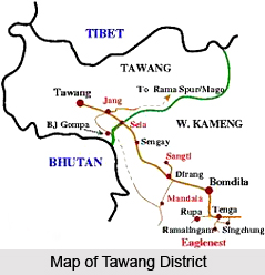
 Geography of Tawang District involves some variations in climatic conditions which occur within short distances, on account of the alterations in the local terrain. Tawang district of Arunachal Pradesh is located between longitude 90 ° 15 minutes East and latitude 27 ° 45 minutes North. West Kameng District in the south-eastern part, Tibet in the north-eastern part and Bhutan in the south-western portion surrounds the Tawang district.
Climate of Tawang District
The maximum part of this Indian district is present in the Higher Himalayan Mountain range, which receives snowfall. The other portions of Tawang district are existent on the mountain slopes of the Lesser Himalayan Mountain ranges which mainly experience pleasant and cool climate.
Topography of Tamang District
The total area occupied by Tawang district is 2085 square kilometre and the forest area measures about 1251 square kilometre. Tamang district comprises two important geographical divisions. One of them involves the snowy Himalayan mountains which possess an altitude of about 11,000 feet to 22,000 feet which consists of uninhabited, bare mountains. The higher altitudes contain mountains which have a height of nearly 6000 feet to 11,000 feet. These mountain ranges comprises valleys and plateau regions, which boast of a scanty populace. The texture of the soil found here is loamy, rocky with a shallow depth. The soil existent here is mostly of a skeletal texture.
This article is a stub. You can enrich by adding more information to it. Send your Write Up to content@indianetzone.com.
