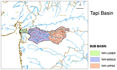
 The Tapti River rises in Madhya Pradesh. The Vindhya Range includes the north central and northwestern boundary of the Peninsula; also the Chota Nagpur Plateau of southern Bihar forms the northeastern boundary of the Tapti River basin. The uplifting of the plateau of the central Peninsula and its eastward tilt formed the Western Ghats, a line of hills running from the Tapti River south to the tip of the Peninsula. The Eastern Ghats mark the eastern end of the Tapti plateau; the river begins in the hills Multapi and converges with the Western Ghats at the Peninsula`s southern tip.
The interior of the Peninsula is mainly the area that lies south to the Narmada River, often termed the Deccan Plateau or simply the Deccan (from the Sanskrit daksina , meaning south), is a series of plateaus topped by rolling hills and intersected by many rivers. The plateau averages roughly 300 to 750 meters in elevation. The major rivers flowing in this plateau are Godavari, the Krishna, and the Kaveri--rise in the Western Ghats and flow eastward into the Bay of Bengal.
The coastal plain borders of the Tapti River the plateau. On the northwestern side, it features tidal marshes, drowned valleys, and estuaries; and in the south by lagoons, marshes, and beach ridges. Coastal plains on the eastern side of Tapti River are wider than those in the west; they are focused on large river deltas that serve as the concentrated zones of human settlement.
This article is a stub. You can enrich by adding more information to it. Send your Write Up to content@indianetzone.com


