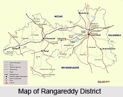
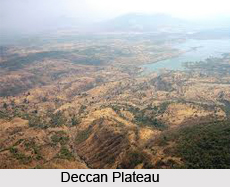
 Ranga Reddy District in Telangana is located in the Central Part of the Deccan Plateau and lies between 16 degree 30 minutes and 18 degree 20 minutes of North Latitude and 77 degree 30 minutes and 79 degree 30 minutes of East Longitudes.
Extension of Ranga Reddy District
Geography of Ranga Reddy District in Telangana is mainly dictated by its location. Ranga Reddy District is bounded on the North by Medak District, East by Nalgonda District, South by Mahabubnagar District, and West by Gulbarga District and North West by Bidar District of Karnataka State. It covers an area of 7564.88 Sq. Kilometres.
Ranga Reddy District in Telangana includes present Hyderabad Urban District that was formerly known as Atrafe-Balda District and was a part of the Gulshanabad, Medak Division (Subah). Ranga Reddy District covers an area of 7564.88 Sq. Kms.
Landforms of Ranga Reddy District
Ranga Reddy District can be divided into three broad basins. A major part (about 65 percent) of the District is covered by the Musi River Basin which rises in Ananthagiri Hills. It flows from West to East, passes through Hyderabad city and flows towards Nalgonda District within the limits of which it joins the Krishna River near Wadapalli (Wazirabad) The next largest basin in the District is the Kanga Basin, a tributary of Bhima River and all new irrigation projects are proposed in this basin. The third basin in the District is the Manjira basin, which is part of the Godavari river basin where the area under irrigation is very limited.
Climate of Ranga Reddy District
Climate of Ranga Reddy District is characterised by a hot summer and is generally dry except during the South west monsoon season. The year may be divided into four seasons: March to May is the summer season; June to September constitutes the South-West Monsoon season, October to December form the North East monsoon season and January to February is the winter season. Ranga Reddy District has a normal rainfall of 781.5 mm. the bulk of which is received through the South-West Monsoon during the period from June to September. The mean maximum temperature begins to rise from the middle of February and reaches a maximum of about 30 degree C in May. With the onset of the South-West monsoon into the District early in June, there is appreciable drop in temperatures and the weather becomes more pleasant. December is the coldest month with the mean daily maximum temperature at 28.6 degree Celsius and the mean daily minimum Temperature at 13.6 degree Celsius. During the South-West monsoon season the relative humidity is generally high, ranging between 70 and 80 percent on the average. Humidity decreases from the post-monsoon season onwards. The driest part of the year is the summer season when the humidity is generally between 30 and 35 percent in the afternoon. Winds are generally light to moderate with some increase in force during May and South West monsoon season.
 Due to the low rainfall and inhospitable soil conditions, the district cannot boast of any important timber-yielding forests. The inferior type of forests (from economic point of view) yield only thorn, fuel and small timber which the soil can sustain. In the Eastern portion of Ranga Reddy District, the forests are mostly restricted to isolated hills while in the western portion, they are confined to the slopes of the hillocks and plateau. The Forest area of Ranga Reddy District forms about 7.63 percent of the total geographical area. The situation of the state Capital in the midst of the District and the high density of population have great bearing on the development of these forests in Ranga Reddy District. The forests of Ranga Reddy District have therefore, receded and generally restricted to hills and slopes where in plough cannot work easily.
Flora and Fauna of Ranga Reddy District
It is on record that, in 1900s Ranga Reddy District with its low shrubby jungles was the home of leopards, bears, hyenas and occasionally tigers while in the more opened plains the antelope were in plenty. The game reserves for the ruling family in the erstwhile Hyderabad State and were stocked with them for the exclusive enjoyment of the nobles. Now the forests have receded into narrow pockets and so also the game. Blackbuck, Chital or Spotted deer and Sambar can still be seen in Rasanam (Rasanam), Dharur (Gingurthi) Tattepalli, Nagulpalle and Thirumalapur (Thirmapur), Gokafeasalwar (Rangampally) Naskal Forest blocks, Wild boar is found all over the forests. Jackal and fox are common even now in the open. Also, Peacock and jungle fowl are seen in Ananthagiri block. Partridges and wild pigeons are common. In the cold season, wild duck, geese, teal and snipe can be seen in the small and large tanks of the District.
Soil of Ranga Reddy District
Red soil predominates in the district followed by Black Cotton soils. The Mandals where more than 50 percent of the villages have Red-Chelka soils are Medchal, Shamirpet, Qutubllapur, Keesara, Hayathnagar, Saroornagar, Uppal, Ghatkesar, Rajendranagar, Pargi, Doma, Shamshabad, Serilingampally, Malkajgiri, Balanagar, Kulkacherla and Gandeed. Dubba soils are largely found in Manchal, Yacharam, Maheshwaram and Kandukur mandals besides Red Chelka soils. The mandals where the soils are predominantly black are Chevella, Shahbad, Vikarabad, Newabpet, Dharur, Pudur, Tandur, Peddemul, Yalal, Basheerbad, Marpally, Mominpet and Bantararm.
Agriculture of Ranga Reddy District
The variation is the fertility of the soils is the main cause for the difference in the cropping pattern of the eastern and western regions in the District. While white Sandy loams occur in the eastern region (Hayathnagar and Ibrahimpatnam), Black cotton soils predominate the western region (Chevella, Pargi, Vikarabad, Marpally and Tandur).The principal crops of the District are jowar, paddy, Ragi, castor and pulses. The food crops account for 83.1 percent and the non food crops for 16.9 percent to the gross area sown in the district. Grape cultivation makes the district occupy the distinct place in the state. Wells form the principal source of irrigation in the district.
Minerals of Ranga Reddy District
In this District, quartz and felspar are the principal minerals. The extensively exploited quartz veins are in the Mandals of Medchal, Maheshwaram, Rajendranagar, Malkajgiri and Pargi. Feldspar, the 2nd principal mineral, is also available in the mandals of Medchal, Hayathnagar, Maheshwaram, Rajendranagar and Malkajgiri around the District Head quarters. Puller earth is also available in Chevella, Vikarabad and Tandur Mandals. Limestone is available mostly in Tandur and Marpally Mandals. In Tandur Mandal, quarries of Lime Stone are extensively developed and the lime is sold locally. Lime Kanker is also available in the villages of Ibrahimpatnam Mandal and it is used as Lime Mortar for building purposes. Clays of different type are also available in Tandur area.


