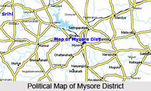
 Mysore district lies in the southernmost part of Karnataka in the Southern maidan region. The region in which the district is found may be classified as partly maiden and partly semimalnad (malnad hilly lands).
The district forms the southern part of the Deccan peninsula with Tamil Nadu to its southeast, the Kodagu district to its west, Mandya district to its north, Hassan district to its northwest and Bengaluru district to its northeast. It lies at an altitude of 610 metres from the mean sea level. The district covers a total geographical area of 6, 76,382 hectares of which 62,851 hectares constitutes the forest land. The net cultivable land is 4, 86,410 hectares and of this 1, 14,010 hectares of land is irrigated.
The prominent river of the district is the Kaveri River. Mysore district is considered as one of the prosperous district of the state based on the development and utilization of irrigation facilities, abundance of forest wealth and sericultural products.
Mysore district lies between 11 degrees 30 minutes to 12 degrees 50 minutes North latitudes and 75 degrees 45 minutes to 77 degrees 45 minutes East longitudes. Mysore district is an undulating tableland with granite rocks protruding at odd intervals. The mountain ranges in the district originate from the Nilgiris along its southern borders and runs in a northwest and northeast direction. There are the Ghats and, in between them lies the Mysore plateau, which is enplane. Except in the north, the district is almost entirely surrounded by the Western Ghats mountain range which at places is an elevation of more than 1200 meters above the mean sea level. Only along the southeast, the mountain ring is broken, where the river Kaveri takes its course towards the Ghats and plunges into the famous Gaganachukki and Barachukki falls at Shivansamudram.
Geologically, the district is mainly composed of igneous and metamorphic rocks either exposed at the surface or covered with a thin mantle of residual and transported soils. The rock formation in the district falls into two groups, charnockite series and granite genesis and gneissic granite. The climate area is agreeable. The climate of the district may be described as essentially tropical monsoon type which is a product of the interplay of the two opposing air-masses of the southwest and northeast monsoons. Over the greater part of the district, summers are languorously warm and winters bracingly cool. The four main seasons applicable to the district are the Cold Weather season, the Hot Weather Season, the South-west Monsoon and North-east Monsoon.
The district in general enjoys cool and equable temperatures. April is the hottest month with the mean daily maximum temperature at 34.5 degree Celsius and the daily minimum at 21.1 degree Celsius. On normal days, the day temperatures during summer may exceed 39 degree Celsius. With the advance of the southwest monsoon about the beginning of June, the day temperatures drop appreciably and throughout the southwest monsoon period, the weather is pleasant. After mid-November, both day and night temperatures decrease progressively. January is the coldest month with mean daily maximum at 11 degree Celsius.
The soils of the districts can be broadly classified as the laterite, red loam, sandy loam, red clay and black cotton soils. The laterite soil occurs mostly in the western part of the district while the red loam is found in the northwest. These two account for nearly half the area of the district. The black cotton soil is found mostly in the north-eastern parts of the district. The red soils are shallow to deep well drained and do not contain lime nodules. The black soils are 1 to 1.5 metre in bases with good water holding capacity for a longer time.
Mysore district is the third richest in forest wealth in the State. The area covered by forest is 4,126.45 sq. km, 34.52 per cent of the total area, of which 3,875.6 sq. km, are reserved forest, and 250.9 sq. km. are classified as forests.
Mysore district has two types of forests and they are moist deciduous where the rainfall is 900-1100 mm and dry deciduous where the rainfall is 700 - 900 mm. The forest belt in the district begins from the western part of Hunsur taluk, spreads along the border of Kerala and Tamil Nadu into the south and east.
The Principal species of trees in the forests are teak, honne, rosewood, dindiga, eucalyptus and sandalwood. The major produce of the forests in the district consists of teak, matchwood, sandalwood, rosewood and building materials. Indirectly, forests of the region confer various ecological benefits on the land such as salubrious climate and good rainfall. They are above all ecosystem habitats.


