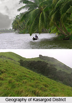
 Kasargod district is situated in the state of Kerala, marked off from the adjoining areas outside the state by the Western Ghats mountain range which runs parallel to the sea. The ghats constitute an almost continuous mountain wall on the eastern side and dominate the topography of the district. The coastline is fringed with low cliffs alternating with stretches of sand. A few miles to the interior, the scene changes and the sand level rises towards the barrier of the Ghats and transforms into low, red laterite hills interspersed with paddy fields and coconut gardens.
Based on the dominant physical features, the district falls into three natural divisions- the lowland, bordering the sea, the mid land consisting of the undulating country and the forest, clad high land on the extreme east. There are mainly four types of soils namely, sandy, sand loam, laterite soil and hill or forest soil. The sandy soil and the sandy loam soil exist as a continuous narrow belt all along the Western coast, about 20 Kms in width.
In a nutshell, the land of the district comprises steep slope hill lands, upland plateau, deep gorges with steep side slope and very narrow valleys, border valleys bounded by subdued hills, coastal plain and marine plain, and nearly level lowland plains along the coastal plain.
The diversity of the physical features results in a corresponding diversity of climate. The climate of the district is classified as warm, humid and tropical. The average maximum temperature is 31.2 degree Celsius and minimum is 23.6 degree Celsius. Though the mean maximum temperature is only around 90 degree F, the heat is oppressive in the moisture laden atmosphere of the plains. Humidity is very high and rises to about 90 percent during the south-west monsoon. The annual variation of temperature is small, the diurnal range is only about 10 degree F. The dry weather is from December to February. March to May is the hot season. The coolest months of the year are January-February. The average rainfall in the district is around 3581 mm. The south west monsoon starts towards the end of May or the beginning of June, heralded by thunder-storms and hold till September when the monsoon fades out. October-November brings the north-east monsoon. Of the total rainfall received, two-thirds of it is experienced in June, July and August.
There are a total of 12 rivers in this flowing through the district. The longest is Chandragiri (105 kms) originating from Pattimala in Coorg and embracing the sea at Thalangara, near Kasaragod. The second longest river is Kariankod (64 kms), across which a dam is being built at Kakkadavu. The others are Shiriya (61 kms), Uppala (50 kms), Mogral (34 kms), Chithari (25 kms), Nileshwar (47 kms), Kavvayi (23 kms), Manjeswar (16 kms), Kumbala (11 kms), Bekal (11 kms) and Kalanad (8 kms) are the other rivers. These rivers provide ample irrigation facilities.
As regards the vegetation of the district, Reserve forests and mangrove forests are to be found in the district. Adoor, Eleri, Karudukka, Maloth, Parappa, Panathady and Muliyar are some of the reserve forests in the district. These forest areas have different types of medicinal plants and shrubs. Once the river-sea joining lands were abundant with the mangrove forests but now they have been limited and are to be seen only in Chittari, Manjeshwar, Mogral, Uppala, Shiriya rivers.


