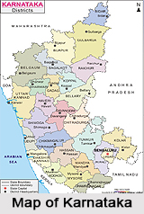
 Geography of Karnataka includes on the western edge of the Deccan plateau and is surrounded on the North by Maharashtra and Goa, on the East by Andhra Pradesh, on the South by Tamil Nadu and Kerala and on the West, it opens out on the Arabian Sea. Karnataka occupies three natural regions like the Coastal strip, the Sahyadris Mountain Range and the Deccan plateau. The Sahyadris are covered with evergreen forests. The state covers an area of 1, 91,791 square km, which constitutes 5.83 per cent of the total geographical area of India. Karnataka lies between 74 degree and 78-degree East longitudes and 11 degree and 18-degree North latitudes.
The state has three physical zones as:
The coastal Karavali
Malnad comprising of the Western Ghats (Western Ghats Mountain Range in India)
The Bayaluseeme comprising of the plains of the Deccan plateau.
The elevation of Karnataka is 1,500 feet. The highest temperature recorded here was 45.6 C (114.08 F) and the lowest recorded temperature was 2.8 C (37.04 F). Karnataka receives an average annual rainfall of 1139 mm. The highest point in Karnataka is the the top of the hill Mullayanagiri, which has an altitude of 1929 mts above sea level.
Karnataka experiences four seasons as
1. Winter - The state experiences winter in January and February. The season is very pleasant.
2. Summer-the state experiences summer during the months of March and May. This season is hot, dry and marked by high humidity.
3. Monsoon - falls between June and September. During the monsoon, the southwest monsoon winds bring rains.
4. Post monsoon - the season is pleasant.
Eleven types of soil orders are found in Karnataka as Entisols, Inceptisols, Mollisols, Spodosols, Alfisols, Ultisols, Oxisols, Aridisols, Vertisols, Andisols and Histosols. Depending on the agricultural productivity, the soil ios divided into seven types as Red, lateritic, black, alluvio-colluvial, forest and coastal soils.


