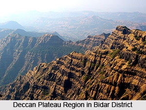
 Geography of Bidar district is determined to a great extent by the general dryness prevalent here throughout the year. The district covers a total expanse of 5548 Kms of land, and lies between 17 degrees 35 minutes and 18 degrees and 25 minutes North latitude and 76 degrees and 42 minutes and 77 degrees and 39 minutes east longitudes. It is bounded on the east by the Nizamabad district and Medak district in Andhra Pradesh and on the west lie the districts of Nanded and Osmanabad in Maharashtra. On the south lies the Gulbarga district of Karnataka.
The entire district forms a part of the Deccan Plateau and is made up mostly of solidified lava. The northern part of the district is characterized by expanses of level and treeless surface punctuated here and there by flat and undulating hillocks, black soils and basaltic rocks. The southern half of the district is a high plateau about 715 m above mean sea level and is well drained. The average elevation of the district is between 580 to 610 metres above mean sea level. Alluvial deposit is normally found along the banks of the Manjra River and its main tributaries. The top layers of the Deccan trap in parts of Bidar and Humnabad taluk are altered to reddish vesicular laterite, forming an extensive undulating plateau. The district falls under two distinct river basins, the Godavari river basin and the Krishna river basin. The main river of the district is Manjra River, which is a tributary of the Godavari River. The Karanja River itself is tributary of Manjra River. These rivers and their rivulets are not navigable.
The climate of this district is characterized by general dryness throughout the year, except during the southwest monsoon. The summer season is from the middle of February to the first week of June. This is followed by southwest monsoon season, which continues till the end of September. The months of October and November constitute the post-monsoon or retreating monsoon season. The winter season is from December to middle of February and the temperature begins to decrease from the end of November. December is the coldest month with mean daily maximum temperature of 27.3 degrees Celsius and mean daily minimum of 16.4 degree Celsius. From the middle of February, both day and night temperatures begin to rise rapidly. May is the hottest month with mean daily maximum temperature of 38.8 degrees Celsius and mean daily minimum of 25.9 degrees Celsius. With the withdrawal of southwest monsoon in the first week of October, there is slight increase in day temperature but night temperature decreases steadily. After October, both day and night temperatures decrease progressively.
The average annual rainfall at Bidar is 847.2mm. About 81% of annual rainfall is received during the period from June to September. Maximum rainfall is recorded in the month of September. The variation in rainfall from year to year is large and the district is drought-prone. The average numbers of rainy days in the district are 52. The relative humidity is high during the southwest monsoon. Summer is the driest part of the year. Winds are generally moderate in strength with some increase in force during the latter half of the summer season and during the monsoon. During the southwest monsoon season, winds mainly blow between the southwest and northeast directions. In the post monsoon season, winds blow predominantly between north and east directions. During the winter season winds are variable in directions.
Two types of soils founds in the district are Lateritie red soil and black cotton soil. Aurad and Bhalki taluks have mainly black cotton soil. Bidar and Humnabad taluks have mainly lateritic red soil. Basavakalyan taluk has both types of soils. The minerals found in the area are Bauxite, Kaolin and Red ochre. A deposit of highly siliceous bauxite clay has been located about three kilometres south of Basavakalyan. Similar deposits are noticed near Alwal and Kamthana Villages of Bidar taluk. A large deposit of Kaolin is located near Kamthana village. Red ochre deposits are found near Sirsi and Aurad Village.
Bidar Forest division is the northern most division of Karnataka encompassing the whole of Bidar district and 31 villages of the adjoining Gulbarga district. Forest areas of Bidar division are classified as Reserve forests, Protected forests and Unclassified forests. Bidar forest division covers about 8.5% of the total geographical area of the district. Most of the Reserve Forest areas are in Bidar and Humnabad ranges. Originally the forests in Bidar Division consisted of Dry deciduous and Scrub type vegetation. Over the years almost all the forest areas have been worked at one or more times resulting in large expanses of man made forests comprising mostly of Eucalyptus, Acacia auriculiformis, Glyricidia and miscellaneous species like Hardwickia, Albizzia, Azadirachta and Pterocarpus etc.


