 Geography of Bhind District mainly consists of valley plains. The plains at present are closely cultivated fields devoid of trees, stubbed with shrubby growth only along the moist hollows, and thickly populated. The network of rivers with deep channels and steep bank offers the only divisions of topography. The widest plane of Bhind District lies in the western part around Gohad, Mehgaon and Mau. The ravine lands extend along both the sides of the rivers and their tributaries. The ravine areas are mostly unsuitable for cultivation and settlements. The entire district lies in the Chambal River valley. It forms the south-western part of Ganga River Valley. The Hills are only a few, small and isolated, mostly in the southwest. Bhind District of Madhya Pradesh is geographically known for its ravines, fertile land and dense forests. It is only in the Bhind Tehsil that the rivers flow towards east.
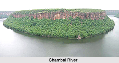
Geography of Bhind District also includes a number of rivers and streams. Chambal River and Sindh River are the main rivers of the district. The Chambal forms the northern boundary. As the two rivers are the tributaries of Yamuna River, they form parts of the Ganga drainage system. Apart from these, the other important rivers of the district are Kwari River, Pahuj River, Asan River and Vaishali River.
The climate of Bhind District is characterized by general dryness, except during the south-west monsoon season. The year may be divided into four seasons. The winter season is from December to February followed by the summer season from March to about middle of June.
The period from middle of June to about the end of September is the south-west monsoon season. October and November constitute the post-monsoon or retreating monsoon season. Average annual rainfall of Bhind District is 668.3 mm. The spatial variation of the district is not too much. About 92 percent of the annual rainfall is received in the south-west monsoon months. On an average, there are 33 rainy days in a year.
There is no meteorological observatory in Bhind District. After February, the temperature increases steadily till May, when the mean daily temperature is about 46 degree Celsius and the mean daily minimum is about 28 degree Celsius. In June, the mean daily temperature is higher by a couple of degrees. The heat in the summer season is intense and the dust laden scorching winds, which blow often, add much to the discomfort. With onset of monsoon in the district by the mid of June, there is an appreciable drop in the temperature. After October, day and night temperature decrease rapidly. January is the coldest month with the mean daily maximum temperature at about 23 degree Celsius, and the mean daily minimum at about 8 degree Celsius. In the cold season in the rear of passing western disturbances, cold waves affect Bhind District and the minimum temperature may drop down to about a degree below the freezing point of water.


