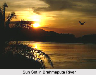
 Geography of Barpeta District varies from low-lying plains to highland having small hillocks in the southwestern corner of the district, namely Baghbar, Fulora and Chatala overlooking the scenic and mighty Brahmaputra River.
The climate of Barpeta remains mild and pleasant round the year. Tropical monsoon climate of this district provides two distinct seasons - hot weather season and cold weather season. The summer season of March to May is followed by the Monsoons from June to September. This is followed by cool winter season from October to February.
River Brahmaputra flows from east to west across the southern part of the Barpeta district. The tributaries of this river that flows through this district are Beki, Manah, Pohumara, Kaldia, Palla, Nakhanda, Marachaulkhowa and Bhelengi flowing from North to South. Rivers Pohumara and Kaldia join near Barpeta town to form river Nakhanda whereas Palla and Beki join with Nakhanda to ultimately form Chaulkhowa River. The soil of Barpeta district may be classified as Sandy, Sandy-loamy and forest-soils. The Barpeta District of Assam covers an area of 3245 square kms and is bounded by international border that is Bhutan Hills in the North, Nalbari District in the East, Kamrup district and Goalpara District in the South and Bongaigaon District in the West. The district is located between latitude 26 degrees 5 minutes North - 26 degrees 49 minutes North and longitude 90 degrees 39 minutes east - 91 degrees 17 minutes East.
Thus, the geography of Barpeta District is spread over vast plain lands with some hillocks in between.
In this district there are major town. These are famous for tourist attraction and also the easy means of communications.
Barpeta: The headquarter and the second largest town in the district. It is virtually a noise and pollution free town with a limited number of automobiles. Rivulets and canals from all directions surround the town. The most important centre of attraction is the Barpeta satra established by Great Vaishnavite saint Madhabdeva. A few years ago, it was also famous for transport industry. However, it has faded a little bit now. It was also famous for ivory working, which is now almost extinct.
Howly: Howly is the largest town of the district. A busy commercial town is also known as the business capital of the district. In this town, Assam`s largest Rash Mela held here. Many communities of people of Assam participate in this Rash Mela. The National highway No 31 runs through this town. A majority of the people in the town have higher education. It is the only town where betel nut (Supari) produce. Many betel nut industries situated here.
Barpeta Road: Barpeta Road is the largest town of the district. A busy commercial town is also known as the business capital of Western Assam.
Sarbhog: A small town along national highway no. 31 that is known for its famous tasty curd made from buffalo`s milk. Many institutions are located in and around the town.
Pathsala: A town in the eastern part of the district is also known as the Hollywood of mobile theatres of Assam. Base camps of many famous and old mobile theatre groups of Assam are situated in the town. A majority of the people in the town have higher education.
Barmara: A small village situated as a transit point between Chenga and Rouly. It is known for its biweekly markets that cater to all the needs of poor and lower middle class people.
Sarthebari: Sarthebari is a small town known for its bell-metal works.
Kalgachia: A town situated in the western part of the district, mainly inhabited by Bengali-speaking Muslim people. It is an important centre of academic and intellectual activities of Bengali-speaking Muslim people of Assam.
Bhawanipur: A town situated near NH31 and the centre place of Barpeta District. It has a good Communication System for the people. It is a well-educated and well-populated town. Mainly Hindus and members of the Muslim community live in the town. The town is known for Bhawanipuria Gopal Ataa Satra and for Sahid Khargeswar Talukdar.
Sarupeta: Sarupeta is a town situated near Bhawanipur Town. It is mainly known as place of business.
Barbhitha: Barbhitha is a small village on the south- west border of the Barpeta District. The specialty of the village is that there is at least one master degree holder in every family. One of the pioneer e-entrepreneurs from North East India, Main Uddin, was also born in this village.


