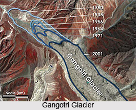
 The major glaciers that describe the Gangotri region are the Gangotri, Chaturangi and Raktavarn, which lie adjacent to each other. Separated from them by massive walls of peaks, there are Satopanth, Bhagirathi and the Arwa valley. Each of them has feeder glaciers, and each feeder glacier has numerous peaks along its walls. Gangotri Glacier is positioned in the Uttarkashi district of Garhwal Himalaya. It is located in snow white surroundings of Garhwal Himalayas, is the birth place of holy river Ganga. At Gaumukh (Cow`s Mouth), the source of the holy Ganges can be observed that is emerging from the depths of the glacier, and the shape of the ice formation is indeed like a cow`s mouth.
Immediately opposite of the Gaumukh is Shivling (6543 metres), a towering pinnacle of rare beauty and of equally severe technical difficulty. It was only after the latest developments in artificial climbing some serious attempts were made on this mountain. Its first ascent by the I.T.B.P. (Hukam Singh) was made in the year 1974. In the year 1980 the Japanese made the ascent from the west ridge and then a traverse under the summit snowfield to the north ridge. In 1981 an Indo-British team (Doug Scott) climbed to the summit via its cast pillar (1200 metres) over extremely exposed ridges. It took them thirteen days to achieve this.
To the east of Gaumukh lies the Manda-Bhrigupanth massif. The Manda peaks are numbered north to south I-III. Manda II is the highest followed by III and I. Manda I (6510 metres) has not been a very popular mountain in spite of its proximity to Gangotri. It was reportedly climbed in the year 1978 by a team from Bengal. A team from Bombay climbing from the Kedar Ganga side reached the summit in 1981 and it was subsequently climbed by the Japanese in 1982 by its north ridge; they also approached their goal from the Kedar Ganga valley. Manda II (6568 m), lying south of Manda I, was ascended in 1982 by P. Udall, P. Athans and P. O`Neil climbing Manda II and III (6529 m) and from there by its south ridge.
Bhrigupanth (6772 m) can be approached either from the west (Kedar Bamak) or from the east (Bhrigupanth Bamak). The first ascent was made in 1980 by a ladies` expedition of mixed nationalities. Thalay Sagar (6904 m) is a fantastic peak by any standards. Its first ascent was made by R. Klicgfield, J. Waterman, and P. Thexton in 1979. But a magnificent route was selected on its northeast pillar by the Polish-Norwegian expedition in 1983. Proceeding southwards along the Gangotri glacier there are the giant peaks of the Bhagirathi and Satopanth massif to the east. At the head of the glacier at its far end lie the mighty Chaukhamba summits. On the western rim of the glacier lie the Kedarnath and Dome, Kharchakund, Sumeru Parbat and Mandani Parbat. Several unnamed peaks dot the peripheral walls of the Gangotri Glacier.
The Bhagirathi peaks I (6856 m), II (6512 m) and III (6454 m) lie fairly close to the junction of Raktavarn and Gangotri glaciers. Bhagirathi II in fact overlooks both, and has been the easiest to approach. Bhagirathi I was first climbed in the year 1980 by a Japanese team via its southeast ridge, who used about 2000 m of rope. A small team of four British friends made an alpine-style ascent in 1983 by its west ridge that gave them some excellent rock climbing on granite and some tricky snow climbing. Some excellent routes on Bhagirathi II and III have been made.
Opposite the Bhagirathi peaks across the Gangotri glacier lay Kedarnath (6940 m) and its Kedar Dome (6831 m). Kedarnath was first climbed by the Swiss Garhwal expedition of 1947. The Dome is a slightly easier proposition and one of the earlier ascents was made in the year 1967 by a team from Bengal which had a multi-disciplined party. Since then the Dome has been a favourite target for climbers. Kharchakund (6612 m) lies further down the Gangotri Glacier from Kedarnath. First climbed in 1980 by the Japanese via the west ridge, it resisted the next attempt in 1982 by a Scottish team. The second ascent was by the northeast wall, by an Austrian team. It repulsed a British party in 1984 and a German team in 1986. The difficult west ridge was finally climbed by a British party (R. Beadle) who reached the summit after a five-and-a-half-day alpine-style ascent in 1987.
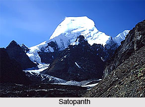
Satopanth (7075 m) lies at the end of the bend of the Gangotri glacier which turns east and northwards. Its massive shape can be seen from most vantage points for miles around. It was first climbed by the Swiss (A. Roch) in 1947 during their well documented Garhwal expedition. Chaukhamba I (7138 m) along with II (7068 m), III (6974 m) and IV (6854 m) form the south and east boundary wall of the Gangotri glacier. It is the highest point in the Gangotri region. It was first climbed in the year 1952 by a French team who approached it from the Bhagirathi Kharak. The second ascent was by an Indian team (Commodore S. N. Goyal) also from the Bhagirathi Kharak, then up the north face and northwest ridge. Since then Chaukhamba I has been climbed three times by Indian expeditions.
The other major glacier, the Chaturangi, is equally well-endowed with climbing prospects. Immediately to the east of the Bhagirathi peaks lies the shapely Vasuki Parbat (6792 m). First climbed by the I.T.B.P. in the year 1973 (L. P. Semwell), it had resisted all comers until 1988 when the Italians (C. Marcello) made the second ascent. Of the recent attempts, there has been one made in 1979 by a Welsh team and another in 1985 by the French by a variation up the northwest ridge. East of Vasuki Parbat there is the less formidable Chandra Parbat (6739 m), which is considered as a beautiful summit for the climber with variations of route in mind. Its first ascent was made by the Germans in 1938; they climbed it by its west ridge without much difficulty. The second ascent was by an Indian team (Pilot Officer Raju) in 1965. Then there is the Raktavarn which offers the possibilities of peaks such as Sudarshan Parbat (6507 m), Yogeshwar (6678 m) and the southern approach to Sri Kailas (6932 m), amongst many other unnamed ones. Sudarshan Parbat had eluded an ascent until the year 1981, by an Indo-French expedition.
Gangotri region of the Garhwal Himalaya is described as a place of huge interest, particularly because of its proximity to the road head and the infrequency of its invasion.


