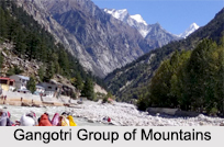
 Gangotri Mountains are a subsection of the Garhwal Himalayas and its peaks are well known as religious destination or for their difficult climbing routes are located here. It rings the Gangotri Glacier, and holds many peaks that are famous for their religious implication to Hindus. Gangotri Mountains are the source of the river Ganga and seat of the goddess Ganga. It is one of the four sites in the Char Dham (pilgrimage centres).
The holy river Bhagirathi acquires the name Ganga from Devprayag onwards where it meets the Alaknanda. The origin of Bhagirathi River is at Gaumukh, set in the Gangotri Glacier. It is the first site in the Char Dham.
Location of Gangotri Group of Mountains
Gangotri group of mountains are located in the northern state of India, Uttarakhand. These are couched in the magnificent Garhwal hills at a height of 3048 meters above sea level. It is approximately 300 kilometres from Dehradun, 250 kilometres from Rishikesh and 105 kilometres from Uttarkashi.
Climate of Gangotri Group of Mountains
The summers of Gangotri group of mountains is usually cool and winters are freezing cold, with rains in the months of May and June. For the devotees and tourists, the gates of the temples are open only in the months of May to November.
Notable Mountains of Gangotri Group of Mountains
Famous mountains of Gangotri Group of Mountains include:
•Chaukhamba: Chaukhamba is a four-summitted massif and Chaukhamba I is situated at a height of 7,138 metres, being the highest peak in the group.
•Kedarnath Mountains: Kedarnath Mountains rises at a height of 6,904 meters and is the highest peak on the southwest direction of the glacier.
•Shivling Peak: Shivling Peak is the most sacred peak in Gangotri Mountains and it represents Lord Shiva. It is situated at an altitude of 6,543 meters above mean sea level.
•Meru: It is situated at a height of 6,660 meters above mean sea level that lies between Thalay Sagar and Shivling Peak. It has some extremely challenging roads.
•Thalay Sagar Peak: It is situated at an altitude of 6,904 metres above the sea level and is the most difficult peak to climb amongst Gangotri Mountains.
Notable Places of Gangotri Group of Mountains
Besides being a mountain range, Gangotri is also a town and a nagar panchayat in Uttarkashi district in the state of Uttarakhand. It is a Hindu pilgrim town on the banks of the river Bhagirathi and is on the Greater Himalayan Range; at an elevation of 3,042 metres. Gangotri town serves as the beginning point of the Gangotri-Gaumukh-Tapovan and Gangotri-Kedarnath trekking routes. Dense forests near Tapovan surround the Bhavishya Badri temple in Gangotri Mountains. Pilgrims trek beyond Tapovan up the Dhauliganga River to reach this holy spot. The idol of "narasimha" (Fourth Incarnation of Vishnu) is enshrined in this Temple of Gangotri Mountains.
According to an old legend, Lord Shiva rewarded King Bhagirath after his penance and Ganga came down to earth. The sacred stone near the temple indicates the place where Ganga first came down to earth. This is why Ganga is also called by the name of Bhagirathi. Submerged Shivlingam is a unique feature at the Gangotri Mountains. The natural rock Shivlingam is submerged in the river and is an amazing sight reinforcing the power of the divine. According to mythology, Lord Shiva sat at this spot and received the Ganga in his matted locks. The Shivlingam is visible in the early winters when the water level goes down. The scenic pilgrimage in the hinterlands of the Himalayas is the most sacred spot where Ganga, the stream of life, touched earth for the very first time.


