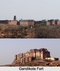
 Gandikota Fort is located in the village of Gandikota in Kadapa or Cuddapah district in the state of Andhra Pradesh. The village is situated on the right bank of the Pennar River and is almost 15 km away from Jammalamadugu. The geographical coordinates are latitude 14.813433°N and longitude 78.284757°E. Gandikota Fort was constructed during late 13th century. The fortress includes temples, mosque, granary and other monuments inside the premises.
History of Gandikota Fort
The region of Gandikota was established by Kapa Raja in 1123 under the Western Chalukyan king of Kalyana named Ahavamalla Someswara I. The fortress is also known as Gorge Fort as it is located near a valley or gorge (gandi in Telegu) between the Erramala range of hills and the Pennar River at the foot of the valley. The fort is surrounded by the deep gorge, impenetrable hills and dense forest. The landscape also includes monolithic boulders of red granite. All these provide a natural line of defence to the residents of the fort.
Architecture of Gandikota Fort
At present, Gandikota Fort lies in ruins. The monument includes a temple, a large granary and a mosque. There are two adjoining towers in the Jamia Masjid. The granary is large and has a vaulted roof. There are 2 ancient Hindu temples in the vicinity of the fort. These temples are devoted to Raghunatha Swami and Madhava Swami.
Gandikota Fort comprises of several other structures, such as, a palace, a magazine, another granary and a pigeon tower which included fretted windows. The palace was mostly constructed with bricks and included plastered decorations. There were also a few wells in the palace. There is also a cannon which is still present in the premise of the fort. There were also many gardens and springs in and around Gandikota Fort. A garden named Parebagh was also present at the foot of the hills. It included a waterfall on the bank of the river Penneru.
This article is a stub. You can enrich by adding more information to it. Send your Write Up to content@indianetzone.com
