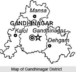
 Gandhinagar district is the administrative capital of Gujarat. The total area of the district is 2,163.48 sq. km. As per 2001 census, the population of this district is 13, 34,731 with a population density of 617 Persons per sq. km. The district headquarters is at Gandhinagar. The district has four talukas, viz. Gandhinagar, Kalol, Dehgam and Mansa. Gandhinagar is divided into 30 sectors formed by roads laid in a rectangular grid with each sector having its own shopping, health, housing colonies and community centers.
Geography of Gandhinagar District
Geographical location of Gandhinagar District is 23.0 degree to 23.6 degree North (Latitude) and 72.3 degree to 73.7 degree East (Longitude). The maximum temperature of this district is 45 degree centigrade and the minimum temperature is 7.5 degree Centigrade. Sabarmati, Khari, Vatrak and Meshvo are the major rivers of this place. Average rainfall of Gandhinagar district is 667 mm.
Education in Gandhinagar District
Gandhinagar district houses some prestigious research and educational institutes such as the Institute for Plasma Research, Indian Institute for Advanced Research and National Institute of Fashion Technology (NIFT). The Institute for Plasma Research in Gandhinagar is an autonomous plasma physics research centre that focuses on research in various aspects of plasma science for industrial applications. The establishment and development of National Institute of Pharmaceutical Education and Research (NIPER) in 60 acres of land in Gandhinagar is in progress. Other premier institutes in Gandhinagar include Dhirubai Ambani Institute of Information & Technology, Entrepreneurship Development Institute of India (EDI), National Law University, Dental College, Santej and Karnavati School of Dentistry.
Economy of Gandhinagar District
Services in the public sector, Electrical & Electronics, Textiles, Food Processing, Ceramics and Office Stationery are some of the major vocational and industrial activities in Gandhinagar district. Electronics and Textiles have been the main sectors of investment and employment in Gandhinagar district since the late 1980s. The Food Processing industry of the district is well developed because of the proximity to agricultural districts such as Mehsana, Sabarkantha, Ahmedabad, Kheda, Anand, etc. Major food crops, produced in the district include rice, wheat, castor, rape and mustard, citrus fruits, ber, guava, pomegranate, papaya, etc. There are approximately 8,000 small scale industries (SSIs) in Gandhinagar providing employment to over 36,000 persons. Textiles, Wood products, Mineral based industries and Engineering are the major SSI sectors of the district.
How to reach Gandhinagar District
By Road
:
National Highway (NH) 8 and 8C runs through the district connecting it with major cities of the State as also with the rest of India. It is connected with Ahmedabad by the Sarkhej- Gandhinagar highway (28 km) and with Vadodara by the Ahmedabad- Vadodara expressway (139 km). Distance from major cities in India by road is Mumbai (573 km), Delhi (943 km), Kolkata (1952 km) and Chennai (1854 km).
By Rail:
Western railways connect Gandhinagar with major cities in India such as Delhi and Mumbai via Ahmedabad.
By Air:
Nearest airport is Ahmedabad which is 22 km away.


