Forests in Northern India are the ones which regionally fall within the ambit of the northern side of India. Himalayan Subtropical Broadleaf Forests in India are the chief Forests in Northern India.
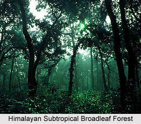
 Several forest types are included in the Himalayan Subtropical Broadleaf Forests eco-region in India. The forest types include the Dodonea scrub, the subtropical dry evergreen forests of Olea cuspidata, the northern dry mixed deciduous forests, the dry Siwalik sal (Shorea robusta) forests, the moist mixed deciduous forests, the northern tropical semi-evergreen forests, and the northern tropical wet evergreen forests. However, among all these, the Himalayan subtropical broadleaf forests in India are noteworthy for their rich diversity of flora and fauna species.
The east-west-directed Himalayan subtropical broadleaf forests in India are located along the Siwaliks or Outer Himalayan Range and lie between 500 and 1,000 m. Though the forests achieve their greatest coverage in the middle hills of central Nepal, a part of them extends through Darjeeling into Bhutan and also into the Indian State of Uttar Pradesh. The eco-region is being bisected by the Kali Gandaki River that has gouged the world`s deepest river valley through the Himalayan Range. The region also forms a critical link in the chain of interconnected Himalayan ecosystems that extend from the Terai and Duar grasslands along the foothills to the high alpine meadows at the top of the world`s highest mountain range.
Mountain Forests in India are mostly located in the Himalayas; the Mountain forests in India play an important role in India`s natural vegetation. Mountain Forests in India are an integral part of the country`s natural vegetation. These forests are mainly located at a high altitude in the mountains and usually vary to a great extent along the slopes of mountain. The Himalayas are the main place where these mountain forests can be found in India. The forests can be found unto a height of 1500 meters, on the foothills of the Himalayas. At this altitude, the evergreen trees like Sal, Teak, Bamboo and Cane grow abundantly and dominate the natural vegetation in mountain forests. The temperate conifer trees like Pine, FIR, Oak, Maple, Deodar, Laurel Spruce, Ceder, etc. grow in plenty on higher slope between 1,500 meters to 3,500 meters and dominate the mountain forests. The plant species like Rhododendrons and Junipers are found at the higher altitude of the Himalayas. The alpine grasslands appear up to snowfield, beyond all these vegetation belts.
 Eastern Himalayan Alpine Shrub and Meadows
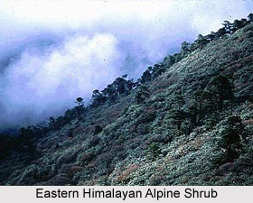
The alpine ecoregion of the Eastern Himalayan alpine shrub and meadows is spread across the countries like India, Bhutan, China, Myanmar, and Nepal. This eco-region lies between the tree line and snow line in the eastern portion of the Himalaya Range and it covers a huge area of 70,200 square kilometres. The eco-region extends along the north and south faces of the Himalaya Range from the Kali Gandaki Gorge in central Nepal and eastwards through Tibet and Indian states like Sikkim, Arunachal Pradesh and Bhutan and northernmost Myanmar. The shrub and meadows lie between approximately 4000 and 5500 meters elevation and permanent ice and snow lies above 5500 meters. The tallest mountains in the world like Everest, Makalu, Dhaulagiri, and Jomalhari are situated within this Eastern Himalayan Alpine Shrub and Meadows eco-region.
Eastern Himalayan broadleaf forests in India
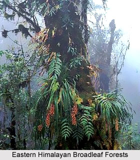
Eastern Himalayan broadleaf forests in India form an eco region that is globally outstanding for both species richness and levels of endemism. The eastern Himalayas are actually a crossroads of the Indo-Malayan, Indo-Chinese, Sino-Himalayan, and East Asiatic floras and also of several ancient Gondwana relicts that have taken refuge here. The eco-region is considered as a biodiversity hotspot for the species like Rhododendrons and Oaks. The forests are spread across the countries like India, Bhutan, and Nepal. In India, these forests can be found mainly in the state of Sikkim.
The Eastern Himalayan broadleaf forests in India are located between 2,000 and 3,000 m elevation and they stretch from the deep Kali Gandaki River gorge in central Nepal, eastward through Bhutan, into India`s eastern states of Arunachal Pradesh and Nagaland. They are playing an important role in maintaining the altitudinal connectivity between the habitat types that make up the larger Himalayan ecosystem. The forests witness several birds and mammals exhibiting altitudinal seasonal migrations. The habitat continuity and intactness of the species are also essential for maintaining the integrity of watersheds along these steep slopes. Several bird species can be found in the temperate broadleaf forests of Bhutan where the habitat is more intact and continuous with the subtropical broadleaf forests lower down.
Western Himalayan Alpine Shrub
The Western Himalayan Alpine Shrub and meadows form an eco region that has large areas of habitat, which are suitable for conserving viable populations of several important fauna species. The eco region is located between approximately 3,000 and 5,000 meters (m) elevation and is situated to the west of the deep Kali Gandaki River gorge in central Nepal and on to the northern Indian State, Uttar Pradesh. About a fourth of this high-elevation eco-region is bare composition of rocks and ice. This eco-region was formed during the early Pleistocene, after a long geological process that thrust up the Inner Himalayas. The eco region receives most of its annual rainfall due to the south western monsoon that also provides most of the moisture, originated from the Bay of Bengal. However, the monsoon expends most of its precipitation in the eastern Himalayas and as a result; the west receives less rainfall, usually ranging from 1,500 to almost 1,900 millimeters (mm). The tree line in this eco-region responds to the drier conditions in the west by being almost 1,000 m lower than in the east.
The Western Himalayan alpine shrub and meadows eco region witnesses` cold winters for a few months every year and during this period, snowfall blankets the slopes. Snow usually melts during the months of April and May and that results in additional moisture. The summers in this eco-region are mild and cloudy days and fog, are quite common here. The natural vegetation in this eco-region is highly influenced by climate and aspect. The north-facing slopes that are less exposed to sunlight are usually cooler and retain more moisture and they also harbour a more typical Himalayan flora. However, the complex topography also creates rain shadows within this general trend and this, results in much localised climatic variations.
 Upper Gangetic Plains moist deciduous forests
Upper Gangetic Plains moist deciduous forests in India lie on the alluvial plain of the Asia`s largest river, Ganges river and also Yamuna river, and cover a huge area of 263,100 square kilometres. The forests form a tropical moist broadleaf forest eco region in the northern India and cover most of the state of Uttar Pradesh and adjacent portions of Uttarakhand, Haryana, Madhya Pradesh and Bihar. The eco-region is bounded by the Himalayan subtropical pine forests, Terai-Duar savannas and grasslands and Himalayan subtropical broadleaf forests of the Himalaya foothills on the north. It is bounded by the drier Northwestern thorn scrub forests and Kathiarbar-Gir dry deciduous forests to the west, on the south by the Narmada River Valley dry deciduous forests of the Malwa and Bundelkhand uplands. It is also bounded by the more humid Lower Gangetic plains moist deciduous forests, on the east.
The Montane grasslands and shrub-lands in India are mainly found in the eco regions like the eastern Himalayas alpine shrub and meadows and the western Himalayas alpine shrub and meadows. The Eastern Himalayan alpine shrub and meadows, lies between the tree line and snow line in the eastern portion of the Himalaya Range. This eco region covers an area of 70,200 square kilometres, and extends along the north and south faces of the Himalaya Range. The Indian states of Sikkim, Arunachal Pradesh are included in this eco region. The alpine shrub and meadows usually lie between approximately 4000 and 5500 meters elevation, and permanent ice and snow lies above 5500 meters. The flora of the alpine shrub-lands are characterised by rhododendrons, which are predominate at lower elevations, close to the tree line. On the other hand, the alpine meadows support a variety of herbaceous plants, above the shrub lands. These plants include the species like Alchemilla, Androsace, Anemone, Diapensia, Draba, Gentiana, Impatiens, Leontopodium, Meconopsis, Pedicularis, Potentilla, Primula, Rhododendron, Saussurea, Saxifraga, Sedum, and Viola etc.
Western Himalayan alpine shrub and meadows
The Western Himalayan alpine shrub and meadows is another alpine eco region, where the montane grasslands and shrub-lands in India are found. The eco-region lies between the tree line and snow line in the western portion of the Himalaya Range. It covers an area of 70,200 square kilometers and is located across Uttarakhand and the eastern Himachal Pradesh states of India. The alpine shrub and meadows usually lie between approximately 3000 and 5000 meters elevation. The flora of these alpine shrub-lands is also dominated by rhododendrons that are predominating at lower elevations close to the tree line. The alpine meadows known as bugyals or bughiyals can be found above the shrub-lands. These support several herbaceous plants, including the species like Anaphalis, Cynanthus, Jurinea, Morina, Potentilla, Gentiana, Delphinium, Meconopsis, Pedicularis, Anemone, Aster, Polygonum, Primula, and Saussurea etc. The fauna of the montane grasslands and shrub-lands in India, in the Western Himalayan alpine shrub and meadows, include the large mammals like Snow Leopard, Bharal or Himalayan Blue Sheep, Himalayan Tahr, Himalayan Musk Deer, and Mainland Serow. Apart from these, some smaller mammals like Weasels and Pikas, are also found here.


