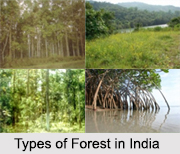
 Types of Forests in India vary depending upon environment, climate, soil quality, topography and altitude. These factors are responsible for natural diversity in forests. Evidently, India has a diverse range of forests: from the rainforest of Kerala in the south to the alpine pastures of Ladakh in the north, from the deserts of Rajasthan in the west to the evergreen forests in the north-east. While classifying the forests into different types, the main factors are taken into consideration which includes soil type, topography and elevation. Forests are also classified according to their nature, the type of climate in which they thrive and its relationship with the surrounding environment.
Various Types of Forest in India
Primarily, there are 8 major groups, namely;
i. Tropical Rain,
ii. Temperate Deciduous,
iii. Moist Deciduous,
iv. Montane Sub Tropical,
v. Montane Temperate,
vi. Sub Alpine,
vii. Alpine and
viii. Littoral and Swamps
They are further subdivided into 16 major types of forests. The various types of forests in India are discussed below:
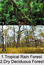
Tropical Rain Forest: Tropical Rain Forests maybe called the lowland equatorial evergreen rain forests. Rainforests are those forests which are characterised by high rainfall between 1750mm and 2000mm. These forests incur heavy showers of 100-600cm a year, and hence the name, Rainforests. For this reason, the soil can be poor because the high rainfall tends to leach out soluble nutrients. The quantity of life found in these forests and its diversity makes them vital. Some of the strangest and most beautiful plants and animals are found in rain forests. They are also the house to a large amount of natural medicines. Rainforests are dominated by the broad-leaved evergreen trees, which form a leafy canopy over the forest floor. Coffee, banana tree , mango tree, papaya tree, avocados and sugarcane all originally came from tropical rainforests.
 Temperate Deciduous Forests: Temperate Deciduous Forests are those, which consist of predominantly broad-leafed trees. Deciduous forests are of two types; Temperate and Tropical. Temperate deciduous forests occur in areas of moderate temperature and rainfall with chilly winters. The tropical monsoon deciduous forests are found in areas receiving an annual rainfall of 100 to 200cms in India, with a distinct dry and rainy season and minimum temperature.
Moist Deciduous Forests: The moist deciduous forests are scattered throughout India except in the western and the north-western regions. They are found extensively on the wetter western side of the Deccan Plateau, the north-eastern part of the Deccan Plateau and the lower slopes of the Himalayan Mountain, on the Siwalik Hills from Jammu to West Bengal. The trees have broad trunks, are tall and have branching trunks and roots to hold them firmly to the ground. These forests are dominated by Sal and Teak, along with Mango, Bamboo and Rosewood.
Dry Deciduous Forests: Indian Dry Deciduous Forests are found throughout the northern part of the country. It is also found in Madhya Pradesh, Gujarat, Andhra Pradesh, Karnataka and Tamil Nadu. The canopy of the trees does not normally exceed 25 metres. The principal trees of these forests are Indian Teak Tree, Sal, Sandalwood, Mahua, Khair, Mango, Jackfruit, Wattle, Arjun, Semal, Myrobalan and Banyan Tree.
 Montane Subtropical Forest: Montane Subtropical Forests are mainly generated in the state of Assam, Nagaland, Mizoram, Meghalaya, Manipur, Arunachal Pradesh, etc. mountain ranges of Western Ghats are also the abode of these types` forests. Some significant trees of Montane Sub Tropical Forest are Cinnamon, Rhododendron, Sal, Sandal, Laburnum, Pomegranate, Olive, Oleander, etc.
Littoral and Swamp Forest: Littoral and swamps are scattered throughout the Andaman and Nicobar Islands, as well as the delta area of the Brahmaputra River and the River Ganga. Usually, mangrove dates, whistling pines, bullet wood and royal palm tree are predominant here. They contain roots that have soft tissues so that the plant can obtain oxygen from the water.
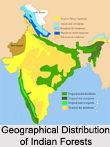
Geographical Distribution of Indian Forests
Eastern zone consists of moist, deciduous and wet evergreen forests. The Western zone forms the other extreme infested with thorn and dry deciduous forests while Northern and Central zones consist mainly of dry and moist deciduous forests. Southern zone incorporates characteristics of both Western and Central zones comprising mainly of thorn dry and eastern highlands moist deciduous forests.
Forests are mostly exclusive and they are indispensable in further existence of life. Forests serve as a home to many species. Deforestation is the reason of global warming.


