 Forest vegetation in South India essentially comprises tropical thorn forests which occupy a considerable area. They exist through out dry peninsular tracts up to the lee side of the Western Ghats. The forests are open, low tree lands with predominance of thorny, usually hard wood, species. The trees have short boles and the crowns are low branching. They rarely meet. The normal height is around 6 to 9 metres. A number of species occur in mixture. The lower storey is ill defined. It consists of smaller trees. Large shrubs with Xerophytic characters, too, occur. Apart from this, spiny, low shrubs also are present. A thin layer of grass grows during the moist season. The soil is barer during the drier months. Climbers are few. They, too, have Xerophytic characters.
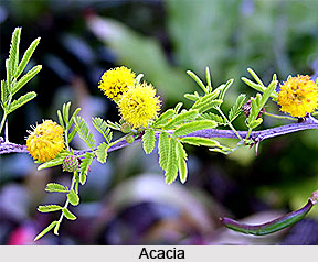
The genus Acacia is characteristic of the vegetation found in this area. Apart from this, a number of other species occur. Several other genera allied to Accacia are characteristic. Fleshy Euphobias are generally present. Species seen here are E. tirucalli, E. nivulis. Euphorbias occasionally form a conspicuous constituent of vegetation. Capparis is also a typical genus. Besides these Ziziphus, Mimosae, Anogeissus, Albizzia, Azadirachta are other important genera present.

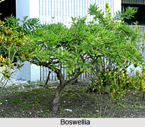
The other forest type occupying the second largest area in this part of the country is tropical dry deciduous forest. This type merges into thorn forests whenever the annual rain fall drops below 750 mm. This happens in a large tract to the leeside of the Western Ghats. Typical annual rainfall for southern tropical dry deciduous forests is 1000 to 1300 mm. It may occasionally go down to as low as 850 mm. On dry or rapidly drained soils this type can occur even with much higher rainfall, frequently going as high as 1900 mm. In teak bearing dry deciduous forests teak (Tectona grandis) is present with typical associates Anogeissus latifolia, and Terminalia spp. In non-teak bearing areas Anogeissus and Terminalias are accompanied by Diospyras, Boswellia and Sterculia. The chief bamboo is Dendrocalamas strictus.
In a linear strip all along the Western Ghats wet evergreen forests are present. They, however, occupy a relatively smaller area in the zone. These are lofty, dense, evergreen forests, 45 metres or higher and characterised by a large number of tree species occurring together. The canopy is extremely dense. Epiphytes are numerous, especially aroids, ferns, mosses and orchids. Undergrowth is often a tangle of canes and creeping bamboo and palms. Leaves are thick and glossy and are very often white or pink when young.
Some evergreen and moist deciduous forests also occupy a small area in the southern side. Typical rainfall for former is 2000 mm to 2500 mm while that for later is 1500 mm to 2000 mm. Xylias, Terminalias and Dipterocarps make the top canopy in case of thje former. In the latter, Terminalias, Pterocapus spp, Lagerstroemia spp, and Adina spp form the top canopy. Ground cover in both is largely made up of evergreen shrubs including various Rubiaceaes and Acanthaceaes.


