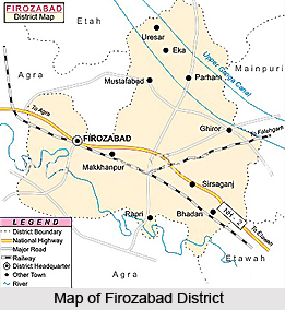
 Firozabad District, an administrative district of Uttar Pradesh, was established on 5th of February 1989. It has its headquarters located at Firozabad town. Firozabad District is situated at 78 degree east longitude and 27 degree north latitude. Its general elevation is 164.467 metres above mean sea level. The boundaries of Firozabad District touch Etah District in north and Mainpuri and Etawah in the east. Yamuna River makes its southern boundary. The area of district is about 8 percent of total area of the state and its total population is around 1.1 percent of the total population of Uttar Pradesh. Approximately 73.6 percent population of the state is living in rural areas. Firozabad District has severe winter and summer seasons. Mostly it comprises plain lands and its slope is from north-west to south.
History of Firozabad District
The ancient name of this town was Chandwar Nager. The name of Firozabad was given in the regime of Akbar by Firoz Shah Mansab Dar in 1566. The tomb of Firoz Shah and ruins of Katra Pathanan are still found in the district. According to the gazetteer of Agra and Mathura in 1596, Firozabad was upgraded in a Pargana. Firozabad was bestowed to Nawab Sadulla as jagir, in the regime of Shah Jahan. Jahangir ruled since 1605 to 1627. Etawah, Budaun, Mainpuri, Firozabad were under emperor Farrukhsiar. Mirza Nawab Khan stayed here till 1782. In the end of 18th century Firozabad was ruled by Himmat Bahadur Gusain with cooperation of Marathas.
French Army chief of Marathas D. Wayan established an ordinance factory in November 1794. In the beginning of British regime, Firozabad was in Etawah district. But after sometime it was attached to Aligarh district. When Sadabad was created a new district in the year 1832, Firozabad was attached to it. Later on 1833 Firozabad was finally made a part of Agra. History of Firozabad District also says that this district contributed heavily in the freedom movement of the country. People of this district actively took part in `Khilafat Movement`, `Quit India Movement` and Namak Satyagrah and other national movements for the country`s freedom. Further, Mahatma Gandhi, and Jawaharlal Nehru visited Firozabad.
Firozabad District has several glass industries. Firozabad District is well connected by railways and roadways with other major cities of the state. The nearest airport is Agra.


