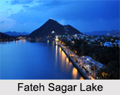
 Constructed in the year 1687 by the former rulers of Mewar for irrigational purposes the Fateh Sagar Lake is a perennial storage reservoir. This artificial lake is named after Maharana Fateh Singh of Udaipur and Mewar and is constructed to the north of the Pichola Lake. It is one of the four beautiful lakes in the city, the other three being the Lake Pichola, Udai Sagar Lake, and Dhebar Lake or Jaisamand Lake.
History of Fateh Sagar Lake
Initially constructed in 1687 by Maharana Jai Singh, but 200 years later the earthen bund which formed the lake was washed away during floods, and thereafter Maharana Fateh Singh in 1889, built the Connaught Dam on Lake Dewali to mark the visit of Duke of Connaught, son of Queen Victoria. The dam enlarged the lake, and it was later renamed as the Fateh Sagar Lake.
Hydrology of Fateh Sagar Lake
The Fateh Sagar Lake is a pear shaped lake and is encircled by the Aravalli Hills on three sides with a straight gravity stone masonry dam on the eastern side which has a spillway to discharge flood flows during the monsoon season. There are three causeways, one from Pichola Lake, the other from Madar Lake and the third one from Badi Lake which leads to the Fateh Sagar Lake. There are also three other inlet channels which feed the lake and an overflow section on the eastern side in the masonry dam of 800 m in length. The main source of water for the lake is the monsoon rains. Initially constructed as an irrigation scheme, it is now the second major source of drinking water to the city of Udaipur and the irrigation supplies have been discontinued. A canal from the Rang Sagar Lake connects to the Fateh Sagar Lake. A gate controlled canal further connects Fateh Sagar Lake with Lake Pichola.
Islands of Fateh Sagar Lake
The Fateh Sagar Lake is embellished by three small islands, which can be reached by taking a boat ride in the lake. The largest island of the lake is developed into a park by the name of Nehru Park. The garden comprises a boat-shaped restaurant and a small zoo for children. This island park is the favourite picnic spot of the tourists and the people living there. The second island is converted into a public park with brilliant water-jet fountains by the Government of Rajasthan. The third island addresses the Udaipur Solar Observatory, which is the best solar observing site in Asia. Fateh Sagar Lake is quiet place where people usually come for relaxation and to lighten up amidst the serene waters of the lake.
Visiting Information on Fateh Sagar Lake
The nearest railway station to the Fateh Sagar Lake is the Udaipur station which is at a distance of 6km. The Maharana Pratap Airport is the closest at a distance of 25 km from the Lake.


