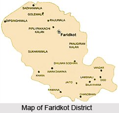
 Faridkot District was part of the then Ferozepur Division but in the year 1996, Faridkot Division has been established with a Divisional headquarter at Faridkot which includes Faridkot, Bathinda and Mansa districts. It is situated between 29 degree 54 feet to 30 degree 54 feet north latitude and 74 degree 15 feet to 75 degree 25 feet east longitude. It lies in south west of Punjab and is surrounded by Ferozepur District in the north-west, Moga and Ludhiana Districts in the north east and districts of Bathinda and Sangrur in the south. Faridkot is the district headquarters. Total area occupied by Faridkot District is 1475.70 sq kms.
History of Faridkot District
Faridkot District derives its name from the headquarters town of Faridkot founded by Mokalsi, grandson of Raja Manj, who ruled this territory during the 13th century and built a fort here. One of the labourers who were engaged in the construction of this fort was Baba Farid. He was observed to possess some miraculous powers. The name of the place was changed to Faridkot after his name. It remained the capital during the reign of Mokalsi`s son Jairsi and Wairsi. The history of Faridkot District pertaining to the ancient period has been traced to the Indus Valley Civilization. A few sites explored in the Moga Tehsil (which is now a separate district) link it with Indus Valley Civilization sites explored in the Rupnagar District. Thus, it can be stated as per the history of Faridkot District that a vast area, including the present area of Faridkot District was under the influence of Indus Valley Civilization.
Geography of Faridkot District
Geography of Faridkot District is composed of low lying flat areas. This district is situated on Punjab Plain constitutes a portion of Sutlej Ganga plain. Surface of the district is depositional plains that were created by mitigation by these rivers. However, geography of Faridkot District does not include any big river although it has a natural drainage system.
 Demography of Faridkot District
As per 2001 Census, total population of Faridkot District is 552466, male population is 293637 and female population is 258829. Further, literacy rate of Faridkot District is 63.34 percent, of which male literacy rate accounts for 68.92 percent and female literacy rate is around 57.09 percent.
Administration of Faridkot District
Deputy Commissioner is the head of administration of Faridkot District. He acts as the Chief Revenue Officer as District Collector and is responsible for collection of Revenue and other government dues recoverable as arrears of Land Revenue. As District Magistrate, Deputy Commissioner is the head of the Criminal Administration of the District and he is responsible for the maintenance of Law and Order in the district. He is assisted by Additional Deputy Commissioner in his day-to-day working. The duties of the Sub Divisional Officer (Civil) within his Sub Division are almost similar to those of the Deputy Commissioner within his district. Administrative set-up of Faridkot District includes two Sub Divisions, two Tehsils and one Sub Tehsils. It has two development blocks - Faridkot and Kotkapura.
Tourism in Faridkot District
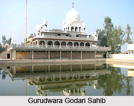
Faridkot District is considered as one of the popular tourist places. Tourism in this district offers the people visits to several historical and holy sites. Some of the prominent attractions of Faridkot District are Qilla Mubarak, Raj Mahal, Darbar Ganj, Gurudwara Tilla Baba Farid, Gurudwara Godari Sahib, Gurudwara Guru Ki Dhab, Gurudwara Tibbi Sahib, Gurudwara Godavarisar Canals, Fairy Cottage and Check Tower. These places are worth seeing.
Headquarter of the district administration, lies on the Firozepur-Bathinda-Delhi Railway line. It is also connected by road with Chandigarh, Ferozepur, Muktsar and Bathinda. Faridkot, Kotkapura and Jaitu towns are linked by railways as well as by roads.


