Home > Indian History > Geography of India > Ennore Port
Ennore Port
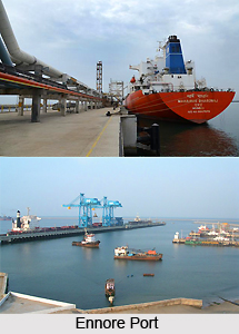
Ennore Port is an important port in South India. This port is officially renamed as Kamarajar Port Limited, a public based company.

Share this Article:

Ennore PortEnnore Port is located on the Coromandel Coast about 24 kilometres north of Chennai Port. Chennai Port is located in Chennai.

Kamarajar Port Limited or Ennore Port is the 12th major port of India. Kamarajar Port Limited or Ennore Port is the first port in India which is a public based company. The Kamarajar Port Limited is the only corporative major port and is registered as a company. The Central Government holds a stake of about 68 per cent in the Kamarajar Port Limited and the remaining 32 per cent is held by the Chennai Port Trust.

Ennore Port has been able to attract the huge foreign and national investment by private entrepreneurs on various terminals and harbour craft. Kamarajar Port Limited is designed as Asia`s energy port. It has only 86 employees.

It is envisaged being a satellite port to decongest and improve the environmental quality at the bustling Chennai Port, Kamarajar Port Limited is evolving itself into a full-fledged port with the capacity to handle a wide range of products. With a permissible draught of 13.5 m, the port handled a total volume of 11.01 million tonnes in 2010–11, up by 2.86 percent from the previous year.

Ennore Port was originally conceived as a satellite port to the Chennai Port, primarily to handle thermal coal to meet the requirement of Tamil Nadu Electricity Board (TNEB) and was endowed with large chunks of land (about 2,000 acres).

The scope of expanding Ennore Port was expanded taking into account subsequent developments taken by the Government of Tamil Nadu. Ennore Port was commissioned by the former Prime Minister of India, Atal Bihari Vajpayee on 1 February 2001. The port was set up under the Companies Act, keeping it outside the scope of the Tariff Authority for Major Ports, the tariff regulator for 11 of the 12 ports owned by the Indian government.

The Government of India and the Government of Tamil Nadu declared Ennore Port as a major port under the Indian Ports Act, 1908 in March 1999 and incorporated as the Ennore Port Limited under the Companies Act, 1956 in October 1999.

Commercial operations commenced with Handymax geared vessels for unloading of thermal coal on 22 June 2001. With the deployment of self-unloading and gearless vessels of 65,000/77,000 dead weight tonnage (DWT), full-fledged operations were started in December 2002.


Share this Article:

Related Articles

More Articles in Geography of India


Geography of Uttar Pradesh
The fourth largest State in India UP is located in the Northern part of India whose area is 2,36,286 sq Kms.
Geography of Maharashtra
Covering an area of 308,000 sq. km, Maharashtra, the third largest state in India.
Geography of Kerala
Geography of Kerala includes plains, hills, valleys and coasts. With the Arabian Sea in the west, the Western Ghats in the east and networked by several rivers, Kerala enjoys diverse geographical features.
Geography of West Bengal
The geography of West Bengal is unique with high peaks of the Himalayan range in the north, the Bay of Bengal in the south and the remaining region is covered with both plains and plateaus.
Geography of Jharkhand
Geography of Jharkhand is comprised of the rich mineral resources and the highly agricultural prospect in this state.
Geography of Sikkim
Geography of Sikkim is characterised by a vast array of magnificent hillock that extends from one corner of the state to the other.
Geography of Meghalaya
The suitable climate, highland plateaus, rivers and the flora and fauna together forms the geography of Meghalaya.
Geography of Mizoram
Mizoram is surrounded by hills, valleys, rivers, waterfalls and lakes. The hills range from 1000 meters to 2000 meters. Rivers, lakes and waterfalls also play major role in forming the land of Mizoram.
Geography of Jammu & Kashmir
Jammu and Kashmir is encompassed by valleys. Some of the dominant valleys of the state are Kashmir Valley, Tawi Valley, Chenab Valley, Poonch Valley, Sind Valley and Lidder Valley etc. Jhelum River is the only major Himalayan River which flows through the Kashmir valley. Indus, Tawi, Ravi and Chenab Rivers are the major ones flowing through the region.
Geography of Daman and Diu
Daman and Diu is situated on the west coast of India and are the smallest union territories of India.
Geography of Goa
Geography of Goa occupies a prime location along the Konkan coastal belt on the western coast of India. The state is bordered by Maharashtra in the north and Karnataka in the south. The Western Ghats in the east contribute to the flora and fauna of Goa.
Geography of Arunachal Pradesh
Geography of Arunachal Pradesh reveals that it is a hilly tract nestled in the foot of Himalayas.
Geography of Kutch
Geography of Kutch District is covering an area of 45,612 km. Kutch District is the largest district in the state of Gujarat.
Geography of Ladakh
Geography of Ladakh mainly comprises the huge Karakoram Range with long stretch of cold desert which mark the region separately from the rest of the states of Indian subcontinent. Surrounded with the mountain ranges from all corners this small region separates Indian subcontinent from rest of the Asian continent.
Geography of Rajasthan
Geography of Rajasthan defines the dry topography with arid climate of the western mountain region.
Geography of Tamil Nadu
The Indian state of Tamil Nadu is located in the Northern hemisphere in the hot zone.