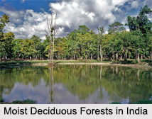
 Located in east central India, the Eastern Highlands moist deciduous forests is a tropical moist region. The characteristics of these forests are that the leaf of the trees here are broad in shape. The region is spread over an area of 341, 100 sq. km. covering the states of Andhra Pradesh, Chhattisgarh, Jharkhand, Madhya Pradesh, Maharastra and Orissa and some parts of Bihar.
It extends from the Bay of Bengal coast in northern part of Andhra Pradesh and southern part of Orissa, covering the northern portion of the Eastern Ghats range and the northeastern Deccan Plateau, to the eastern Satpura Range and the upper Narmada River valley. Geologically, the forest dates back to the Cretaceous and has Gondwanaland origins. The forests are recognized globally for the rich and varied fauna and ecological processes that they still support.
 The Bay of Bengal lies in the southeast, which brings the moisture bearing monsoon winds and provides moisture to the forests. On the north and the west it is bounded by the tropical dry deciduous forests, the Central Deccan plateau dry deciduous forests to the southwest and west, the Narmada valley dry deciduous forests to the northwest and the Chota Nagpur dry deciduous forests to the north and northeast. On the Eastern Ghats range, the Eastern Highlands moist deciduous forests surround the drier Northern dry deciduous forests.
The ecoregion`s forests are dominated by Sal. The flora of the forests shares much of the features with the moist forests of the Western Ghats and the eastern Himalayas. The fauna of the region consists of tigers, wolf, gaur and sloth bear. The Asian Elephant, which was the largest terrestrial vertebrate, has become extinct from this region. Twenty five percent of the forest area can create large conservation landscape that can support species of animals like tigers.
Three hundred and thirteen species of birds inhabit the forest area, out of which two are endangered species the green avadavat (Amandava formosa) and Pallas`s fish eagle (Haliaeetus leucoryphus). The other threatened and interesting species supported by the forests are Arisaema tortuosum, Cyathea gigantea, Entada rheedii, Gnetum ula, Rauvolfia serpentina, Musa rosacea, Linociera ramiflora, Dioscorea anguina, Litsea monopetala, and Didymoplexis pallens and the endemic Leucas mukerjiana and Phlebophyllum jeyporensis.
About three fourth parts of the natural forests of this ecoregion have been cleared. The remaining forests are in several large blocks that exceed 5,000 sq. km. There are thirty-one protected ecoregions, which cover more than 13,500 sq. km. or about 4% of the ecoregions intact habitat. The largest protected area, Simlipal, covers an area of 2,000 sq.km. and Kawal and Indravati are just over 1,000 sq. km. Kanha, is one of the most important tiger reserves in India, covers an area of 1,000 sq.km. But twenty-three of the thirty-one reserves are less than 500 sq km. in extent.
The main source of threats to these remaining habitat blocks come from quarries, coalmines, hydroelectric projects and slash and burn cultivation.


