Home > Indian History > Geography of India > East Coast Railway
East Coast Railway
Bhubaneswar forms the connected to major cities of the country. And Indian Railways have had a profound impact on all the up-gradation of the city.

Share this Article:

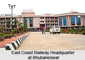
East Coast Railway, BhubaneswarTo meet the growing demand for transport facilities the East Coast Railway, with its headquarters at Bhubaneswar, came into existence in the year 1996. Besides Bhubaneswar the East Coast Railway has its divisions at Khurda Road, Sambalpur and Waltair. Both express and mail trains available from the stations of the East Coast Railway, Bhubaneswar. Srikakulam, Vizainagaram and Visakhapatnam districts can also be accessed by East Coast Railway. This forms as the epicenter for the purpose of communication for people. Bhubaneswar, the capital of the state of Odisha, has its connectivity to all major cities of the country.

For moving in the city itself there are umpteen numbers of local trains that ply all though the day. These trains are availed by most of daily commuters as they are cheap and offer good service.

There are several express trains that ply to and from Bhubaneswar, Puri, Howrah, Delhi, Sambalpur and others. The trains plying for East Coast Railway provide access to several pilgrimage places, such as, Puri, Haridwar, Amritsar and others. Besides the regular train service there are special trains as well. Prior reservations are required to avail these trains. To ensure a comfortable journey for the passengers facilities like cloak rooms, computerized reservation services, medical assistances, etc have been arranged by the administrations. Indian Railways in the recent times have provided people with all the major facilities. All the East Coast Railways have underwent a major revamp and the infra structure have been upgraded. Most of the stations in East India have state-of-the-art services, with ATM counters and other major facilities also available.


Share this Article:

Related Articles

More Articles in Geography of India


Geography of Uttar Pradesh
The fourth largest State in India UP is located in the Northern part of India whose area is 2,36,286 sq Kms.
Geography of Maharashtra
Covering an area of 308,000 sq. km, Maharashtra, the third largest state in India.
Geography of Kerala
Geography of Kerala includes plains, hills, valleys and coasts. With the Arabian Sea in the west, the Western Ghats in the east and networked by several rivers, Kerala enjoys diverse geographical features.
Geography of West Bengal
The geography of West Bengal is unique with high peaks of the Himalayan range in the north, the Bay of Bengal in the south and the remaining region is covered with both plains and plateaus.
Geography of Jharkhand
Geography of Jharkhand is comprised of the rich mineral resources and the highly agricultural prospect in this state.
Geography of Sikkim
Geography of Sikkim is characterised by a vast array of magnificent hillock that extends from one corner of the state to the other.
Geography of Meghalaya
The suitable climate, highland plateaus, rivers and the flora and fauna together forms the geography of Meghalaya.
Geography of Mizoram
Mizoram is surrounded by hills, valleys, rivers, waterfalls and lakes. The hills range from 1000 meters to 2000 meters. Rivers, lakes and waterfalls also play major role in forming the land of Mizoram.
Geography of Jammu & Kashmir
Jammu and Kashmir is encompassed by valleys. Some of the dominant valleys of the state are Kashmir Valley, Tawi Valley, Chenab Valley, Poonch Valley, Sind Valley and Lidder Valley etc. Jhelum River is the only major Himalayan River which flows through the Kashmir valley. Indus, Tawi, Ravi and Chenab Rivers are the major ones flowing through the region.
Geography of Daman and Diu
Daman and Diu is situated on the west coast of India and are the smallest union territories of India.
Geography of Goa
Geography of Goa occupies a prime location along the Konkan coastal belt on the western coast of India. The state is bordered by Maharashtra in the north and Karnataka in the south. The Western Ghats in the east contribute to the flora and fauna of Goa.
Geography of Arunachal Pradesh
Geography of Arunachal Pradesh reveals that it is a hilly tract nestled in the foot of Himalayas.
Geography of Kutch
Geography of Kutch District is covering an area of 45,612 km. Kutch District is the largest district in the state of Gujarat.
Geography of Ladakh
Geography of Ladakh mainly comprises the huge Karakoram Range with long stretch of cold desert which mark the region separately from the rest of the states of Indian subcontinent. Surrounded with the mountain ranges from all corners this small region separates Indian subcontinent from rest of the Asian continent.
Geography of Rajasthan
Geography of Rajasthan defines the dry topography with arid climate of the western mountain region.
Geography of Tamil Nadu
The Indian state of Tamil Nadu is located in the Northern hemisphere in the hot zone.