 Districts of South Bihar include the districts like Aurangabad District, Gaya District, Jamui District and Nawada District. The districts are under developed and are under the map of Red Corridor. The Red Corridor is a region in the east of India that experiences considerable Naxalite-Maoist insurgency. The Naxalite group mainly consists of the armed cadres of the Communist Party of India (Maoist). These are also the areas that suffer from the greatest illiteracy, poverty and overpopulation
Aurangabad district
Aurangabad district is one of the thirty-eight districts of Bihar state. It is currently a part of the Red Corridor
Gaya District
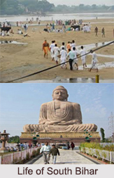
Gaya District is one of the thirty-eight districts of Bihar state. It was officially established on 3rd October 1865. The district has a common boundary with the state of Jharkhand to the south. Gaya city is both the district headquarters and the second-largest city in Bihar. Gaya District and its headquarter Gaya is one such place that is close to the heart of those who follow Hinduism, Jainism and Buddhism. It is the best place to admire the wonders of the world of the ancestors from the Maurayn era. Gaya is still a great choice as the land has some of the best constructions that highlight the architectural brilliance of an era in the past. Gaya is famously associated with Gautama Buddha, a prince who turned down his right to throne to rule the hearts of millions who were sick, homeless and who believed in him as their saviour. Bodh Gaya, famously referred to as Gaya, welcomes the global tourist to its attractions. There are many across the world who follow Hinduism and Buddhism and frequent the land, as it is considered a place of importance going by the epic Ramayana and it is where Buddha made the Fire sermon. For nature lovers, the place holds attraction as it is located in a dramatic setting amidst hills thus presenting a picturesque countryside that is both serene and stimulating. Mahabodhi Temple, Vishnupad Temple, Dungeshwari Cave Temples, Barabar Caves, Bodhi Tree, Chinese Temple And Monastery, Bodhgaya Archaeological Museum, Muchalinda Lake, Thai Temple And Monastery, Royal Bhutan Monastery are the important places of attractions in Gaya.
Jamui District
Jamui District is one of the 38 districts of Bihar. The district was formed on 21st February 1991, when it was separated from Munger district. It is located at a longitude of 86 degree 13 minutes East and the latitude is 24 degree 55 minutes North.
Nawada District
Nawada district is one of the thirty-eight districts of the Indian state of Bihar. Nawada is its administrative headquarters. The district is the westernmost district of the Magadh division, one of the nine administrative divisions of Bihar. The area of the modern district was historically part of the Magadha, Shunga and Gupta empires. Koderma and Giridih districts of the state of Jharkhand lie on the southern border of the district; it also shares borders with the Gaya, Nalanda, Sheikhpura, and Jamui districts of Bihar.


