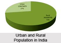
 Distribution of population in urban and rural India is unequal and has differences. India is primarily an agrarian society, where majority of the population are dependent on agriculture and allied activities in rural areas. In the urban areas of the country, people are not dependent on agriculture. Normally an urban area is one in which 75 percent of the population lives by non-agricultural occupations but in the beginning of 20th century this was not the case in India. In 1901, only 1 out of every 9 Indians lived in towns or cities. Today, after so many decades the situation has experienced remarkable changes. Today every fourth Indian is a city-dweller. In 1901, the sum total of people living in urban areas was around 26 million. By 1991, the number of people living in urban areas had escalated up to 218 million. This figure far surmounts the total population of Russia, Canada and Australia taken together. More alarming is the fact that two third of India`s total urban population lives in metropolitan and developing cities that have a populace of several lakh people. This ever increasing population exerts terrific pressure on the existing brittle civic, social and sanitary services.
According to the 2001 census, the total population in rural areas of India is 742,490,639, which is 72.2% of the total population. Where as total urban population is 286,119,689, which is 27.8% of the nation`s entire population. The population in the metropolitan cities of India are 16,368,000 in Mumbai, 12,791,000 in Delhi, 13,217,000 in Kolkata and 6,425,000 in Chennai as per the 2001 census.
At present in India, the ten leading populated urban districts include Kolkata, Chennai, Mumbai, Hyderabad, Delhi, Chandigarh, Pune, Bengaluru, Ahmedabad and Kanpur. These ten city districts alone account for more than 5 percent of the total population of the country. The average density of these districts is around 6888 persons per sq km. Among the large states like Maharashtra, Gujarat and Tamil Nadu are considered as the most urbanised states. More than 35 percent of the total population of these states lives in cities. Another fact of enormous significance is the fast development of major cities. Each of such cities has more than one million people. In 1981, there were 12 such cities. However, their number had risen to 23.
The rural population in India comprises the core of Indian society as almost 70% of the population lives in the 6, 27,000 villages of rural India. Religion, caste and language are considered the major determinants of social and political organisation in rural India. More than 80% of the total rural population in India is Hindu and the other major religious communities include the Muslims, Buddhists, Jains, Christians, Sikhs, Parsis, etc. Tribal or adivasis are an integral part of the rural population as well. The State and Central Governments are taking various steps and measures to improve quality of life and provide adequate basic amenities like proper accommodation, food, clear drinking water, healthcare, sanitation and most importantly education. Banks have also been invited by the Government to provide support in rural development.
Over a period of 90 years, the rural population has barely increased. During the same time, urban population had amplified by more than eight times. Today`s urban population in India is even greater, compared to the total rural population of India, as it was in 1901. When population in India was expanding very swiftly, the percentage of young population accounted for as much as near about 44 percent of the whole population. However, it had declined over the years. The old population over the last decade has enlarged from around 6.2 percent to 6.76 percent. This is a hint that due to propagation of education and magnified and bettered health services, the normal longevity has been increasing steadfastly. The average life expectancy has now nearly doubled since 1951 for both males and females.
Education, health and medical care of the young and the old make an imperative demand on the resources of the economically dynamic population. Further more, both the groups are dependent on the population of the middle-age group. The dependency ratio is measured by dividing the dependent population by the active population and multiplying it by 100. Another important aspect regarding the distribution of population is that traditional rural-urban migration prominently exists in India.


