 Dinhata is the sub divisional headquarters of the Cooch Behar district of the eastern state of India, West Bengal.
Location of Dinhata
Dinhata is situated 20 kilometers south of Cooch Behar District of West Bengal. This sub-divisional town is well connected to other parts of the state. Dinhata is located between 26.13 degree North latitude and 89.47 degree East longitude at a height of 36 metres (118 feet) above mean sea level.
Demography of Dinhata
According to the 2001 census report, Dinhata had 34,303 inhabitants. The males constitute 51 percent of the population and females 49% of the population. In Dinhata, 9 percent of the population is less than six years of age. Dinhata has an average literacy rate of 80 percent which is higher than the national average of 59.5 percent. The male literacy rate is 84 percent and, female literacy rate is 75 percent.
Tourism in Dinhata
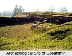
Gosanimari is a nearby tourist attraction in Dinhata. Kamteswari Temple is about 8 km from Dinhata.
Visiting Information
Dinhata is easily connected with both roadways and railways from Kolkata, Sealdah and Howrah District. Dinhata Railway Station which is the nearest railway station is on the Alipurduar - Bamanhat rail route. Civil Enclave Bagdogra is the nearest airport to Dihata.
This article is a stub. You can enrich by adding more information to it. Send your Write Up to content@indianetzone.com