 Dhule district lies in the northern side of the state of Maharashtra. The district in general and the town in particular are famous for the production of pure milk. Milch cattle used to be fed with cotton pend (cattle feed made by using cotton extract), which would produce rich quality milk. Customers in Delhi once upon a time used to wait for the delivery of milk from Dhulia. Dondaicha in this district is the only town in the State to produce glucose sugar and other products from maize. Laling fort, Tirupati Balaji temple of Shirpur, Nakane Pond, Rajwade Sanshodhan Mandir is places of tourist interest. Dhule district has been known for cash crops like, cotton and chillies. More details about the district are provided below.
Location of Dhule District
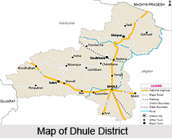
Dhule District is located in northern side of Maharashtra state. It lies between the latitudes of 20 degrees 38 minutes and 21 degrees 61 minutes north and the longitudes of 73 degrees 50 minutes and 75 degrees 11 minutes east. Dhule district is bounded by the district of Nandurbar in the North-West, Nashik district in south and Jalgaon district in East. It is Located at the crossing of three National Highways namely NH-6 (Surat - Nagpur), NH-3 (Mumbai - Agra) and NH-211 (Dhule - Solapur).
History of Dhule District
 History of Dhule district goes back a rather long way. In its earliest times, it was known as Khandesh. Dhule district has seen the rule of a number of different dynasties in the long course of its history. These include the Yadava dynasty, Maurya empire, Sunga dynasty, Vakataka dynasty, Chalukyas of Badami, Rashtrakuta dynasty and the Yadavas of Devagiri. It came under Muslim rule in 1296 AD when Ala-ud-din Khilji invaded the territory. Consequently, the territory was under Mughal, Maratha and British regimes. In the year 1906 for administrative purposes, Khandesh was divided in o two districts known as West Khandesh and East Khandesh, and Dhule remained a part of the former. In 1960 Dhule became a part of Maharashtra state from old Bombay state. The district of Dhule as it exists today was finally created in the year 1998 by dividing the earlier Dhule district into two separate districts of Dhule and Nandurbar.
Economy of Dhule District:
Agriculture is the backbone of the economy of the district. In the Urban Area of the District 50 to 75 percent of the population is made up of agriculturalists and agricultural labours, where as in the rural area more than 95 percent of the population comprises the same. Due to drought conditions of the district and absence of major industrial growth, most of the agricultural labourers are seen migrating in the nearby districts and states like Gujarat and Madhya Pradesh, generally in the months of October to March in the year.
Geography of Dhule District
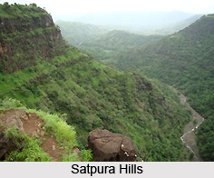
Dhule District covers a total area of 8061 Sq.Kms. The district has one major river basin, the Tapi basin. Bounded on the north by the Satpura hills, the height of the district varies from 300 to 600 Metres above mean sea level. The Soil has an alluvial and loamy nature. The climate of the district is hot and dry. Taking the district as a whole, groundnut, cotton and jowar are the important crops, with some sugarcane and chillies under irrigation. Flat mud topped houses are the rule in the rural parts and in the eastern parts of drier climate. However, out of the 15 talukas of Maharashtra sharing the highest proportion of dwellings with walls of grass, leaves etc., three are in Dhule district, viz., Akrani, Akkalkuva and Navapur. These talukas are well-known hilly habitats of scheduled tribes and have large areas under forests.  Throughout the district the neem trees have been planted as avenue trees on roadsides. Less common is the tamarind and other trees are seldom to be found
Tourism in Dhule District
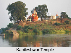
Tourism in Dhule district has a lot to offer the tourists. The prominent tourist attractions in the district can be found in the form of temples and forts. There are many beautiful and ancient temples located here which are visited by many pilgrims. These include the Gangeshvar temple at Chikse, the ancient temple at Indave, the Kapileshwar temple at Mudavad near the confluence of the Tapi and Panjhara built by Ahilyabai Holkar, the Nagai temple on the left bank of the Pajhara river in Nagpur Kokale, the Hemadpanthi temples at Nizampur and Shirud etc. Among the forts are the ones at Bhamer, Laling and Songir. Shri Samartha Vagdevta Mandir is a valuable storehouse of manuscripts, letters and chronicles of historical importance. It is visited by tourists from near, far and even outside the country.


