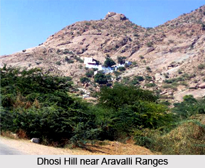
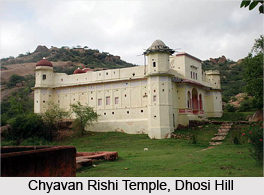
 Dhosi Hill is located on the north-western part of the Aravalli Mountains, particularly along the southern portion of Haryana and northern part of Rajasthan and is renowned for being an extinct volcano. Visitors will come across a distinctive crater and lava lying over Dhosi Hill, which also bears a religious significance as this spot is believed to be associated with the growth of the `Sanatana Dharma`, the oldest religion of the entire world, now recognised as Hinduism. Dhosi Hills have been mentioned in the Puranas, Brahamanas and also the Mahabharata. It is here that the `ashram` of Rishi Chyavana (for whom the famous Ayurvedic tonic `Chyawanprash` was made) existed, which dates back to over 10, 000 years. The Rajasthan area of Dhosi Hill is situated in Jhunjhunu District while the Haryana part of the Dhosi Hill, Mahendragarh District is based at a distance of nearly 5 kms away from Narnaul, on Singhana Road. However Dhosi Hill is referred to as `Pahadi Dhusran` or `Hill owned by `Dhusars`. Dhusars are said to be Brahmins and Vaishyas who are descendants of Bhrigu Rishi and Chyavana Rishi.
Eruption of Dhosi Hill
Dhosi Hill had erupted during the initial phase of the `Treta Yuga`, according to the accounts of Mahabharata, as explained by Guru Shashank who had given the Pandavas company during their exile about 5100 years ago. This region was known for having erupted, and later Munis and Rishis started inhabiting Dhosi Hill.
 Floods in Dhosi Hill and Composition of Manusmriti
Due to the rapid melting of glaciers and rivers throughout the world during the first part of the Holocene age and towards the conclusion of the last Ice Age which can be traced back to more than 10, 000 years ago, floods occurred in Dhosi Hill. This caused violent destruction which finds a mention in `Avesta`, a Persian book as well as in numerous Vedic Granths or Sanskrit journals. This area of land was recognised as `Brahmavarta` and also `Devbhumi` following the floods, in the `Manusmriti` and they were believed to have asked the seer Manu to guide them as to how to tolerate the various calamities and complications which life poses now and then, in a simplified and systematic manner. It was a conglomeration of famous saints of that time, held in Brahmavarta. Bhrigu and Manu had narrated the different spheres of life which had been composed into a written document called Manusmriti.
Dhosi Hill as an Ayurvedic Centre
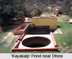
Since the Vedic period, Dhosi Hill was a crucial Ayurvedic spot mainly due to the presence of fertile soil on this volcanic hill. Numerable types of unique herbs are found here though presently the Panchayat herbs are getting destroyed due to activities like indiscriminate chopping of trees and also grazing by animals. The Chyawanprash was manufactured here with the aide of 46 herbs and is the most ancient and effective Ayurvedic herb during 10, 000 years ago by `Ashvini Kumar` brothers who were `Raj Rishis` or royal `Vaids` for curing skin ailment of Chyavana Rishi. This place is also revered for possessing the `Kayakalp` which enables one to obtain a glowing and nourished skin and this tonic is believed to have granted a youthful appearance to Chyavan Rishi. This was made possible by the Ashwini brothers who had prepared it, which has been spoken about in the Puranas, Mahabharata and the Brahmanas. Even today the water of the local pond near the hilltop is said to be beneficial for rejuvenation. This water is enriched with copper and dissolved herbs which make it immensely helpful for digestion and healing skin and eyes.
 Fort of Dhosi Hill
The ruins of a fortress constructed by king Hem Chandra Vikramaditya or Hemu about 500 years ago which possesses thick walls measuring upto 25 feet in height and 40 feet in width. Such strong walls were built all around the fort in order to protect the fortress from numerous attacks by Islamic invaders during medieval era. The fort stairs have been composed of lime plaster and stone on Thana and Kultajpur sides of villages. `Shekhawati` paintings are present in the Chyavana Rishi Temple which is located nearby. Presently the Government of Haryana has arranged for drinking water at the base of Dhosi Hill alongside the Thana village side.
Shiva Kund and Sankrit Sansthan of Dhosi Hill
A sacred water reservoir called `Shiv Kund` is existent on the summit of Dhosi Hill near Kultajpur village. The regional Mittal community manage the Shiv Kund. There also present a Sanskrit Vidyalaya close to it which was completely functional even till three decades back.
Sarovar of Dhosi Hill
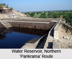
Dhosi Hill also contains an old reservoir or `Sarovar` which is utilised for conserving rainwater used for the purpose of bathing of the pilgrims. It is believed that the rainwater preserved in this sarovar is enriched with medicinal properties which are great for curing skin ailments. The water of this sarovar is actually herbal due to the presence of copper in it. The reservoir is disilted frequently. A concrete dam was constructed on the site. A plaque placed above the dam which demarcates that the reservoir can be used by Hindus including Sikhs, Buddhists, Jains, Harijans, Arya Samajis and people of Sanatan Dharma for bathing.
 Religious Significance of Dhosi Hill
The Hindus respect Dhosi Hill ever since its eruption and most of the devotees perform a `parikrama` of this Indian hill. Guru Shashank had asked the Pandavas to practise a parikrama of this hill, and demonstrated how this must be performed. Land slides have brought about the destruction of the majority of the parikrama regions.
Swami Vivekananda`s Association with Dhosi Hill
The renowned Hindu saint and reformer Swami Vivekananda had resided in a guest house at Dhosi Hill atleast thrice during his visit to the Raja of Khetri Ajit Singh. This was during the period around 1890`s, and the stay was for three months.
Tourism of Dhosi Hill
The crater can be approached from three or four routes and two of them are from Thana village. One can avail ponies from the side of Thana village, though this pathway is presently destroyed at several places due to land slides and soil erosions. The ideal route to ascend up the hill is from the fourth pathway from the end of Kultajpur village which is equipped with broad stairs.


