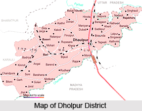
 Dholpur district is a prominent district of Rajasthan and its administrative headquarters is at Dholpur. Surrounded by Agra district of Uttar Pradesh in the north east, Morena District of Madhya Pradesh in the south, Karauli District of Rajasthan in the west, and Bharatpur District of Rajasthan in the northwest it covers a total area of 3,084sq. Km. The Chambal River flows through the southern boundary of the district. It receives an annual rainfall of 67 cm. and is one of the hottest places in Rajasthan. The nearest airport is at Agra.
According to the 2001 census report, the population of the district is 982, 815 inhabitants with a population density of 324 persons per sq. km. The literacy rate of the town is 60.1%. The male literacy rate is 75.1% and the female literacy rate is 41.8%. For administrative purposes the district is divided into four subdivisions Dholpur, Badi, Rajakhera, and Basedi, and five tehsils, Dholpur, Badi, Rajakhera, Basedi, and Saipau.
Primarily thriving on agriculture the main crops grown here are bajra, paddy, sugarcane, wheat, barley, pulses, red chilies and guar seed.
Laswari, Shergarh Fort constructed by Sher Shah Suri, Talab Shahi (a historic lake known forits scenic beauty 40 km. from Dholpur), Khanpur Mahal, the pleasure house of Shahjahan, Shiva Temple, Ramsagar Wildlife Sanctuary and Van Vihar Wildlife Sanctuary are the prime attractions of the district. Machchhkund, an ancient sacred place around 8 km. from Dholpur is a major excursion site in the neighbourhood.


