 Dhalai District is the youngest administrative district in Tripura. It was created in the year 1995. Dhalai District was initially a part of North Tripura District. The district headquarter is situated at Ambassa which is around 90 kms from the state capital Agartala. The District is rich in natural resources. This district is known for its scenic beauty.
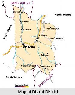
Geography of Dhalai District
Geography of Dhalai District comprises mostly hilly and forest covered areas. Topographical features of Dhalai District include huge natural resources, favourable climate as well as adequate and well spread rain fall, huge human resources. It also comprises vast water areas including four major rivers. Maximum temperature recorded in the district varies from 36 degree Celsius to 28 degree Celsius and minimum temperature ranges from 17 degree Celsius to 6 degree Celsius. Average rainfall of the district is 220 cm. Major rivers of Dhalai District are Gomti River, Khowai, Dhalai and Manu. Geography of Dhalai District is also characterized by major hills namely Atharamura, Longtharai, Kalajhari and part of Sakhan.
Demography of Dhalai District
According to the Population Census in the year 2011, Dhalai District had population of 377,988 of which male and female were 194,342 and 183,646 respectively. Dhalai District population constituted 10.30 percent of total Maharashtra population. The average literacy rate of Dhalai in 2011 was 86.82 compared to 60.93 of 2001. If things are looked out at gender wise, male and female literacy were 92.45 and 80.83 respectively. The total literate in Dhalai District were 280,930 of which male and female were 154,161 and 126,769 respectively. In 2001, Dhalai District had 158,397 in its district.
Economy of Dhalai District
Dhalai District is predominantly an agricultural district and thus its economy is mainly dependent on agriculture and agricultural based activities. The major crops grown in the district are Paddy, vegetables and horticulture plantations. Around 75 percent of the total land is classified as forest land. Around 53 percent of the landscape is classified as hilly land. Due to the large proportion of forest area the land available for cultivation is very restricted. Agriculture is the mainstay of the district and a large number of families are dependent on jhum (shifting) cultivation.
Culture of Dhalai District
Culture of Dhalai District is basically tribal in character. Major tribes inhabiting in Dhalai District are Tripuri tribe, Reang, Kuki tribe, Koloi and Chakma tribe. Rash Fair is an attractive fair and an important part of the culture of Dhalai District. Rich culture of this district also includes some attractive dance like Lebang Bumani, Dhamail of Bengali community and Hajagiri (Dance of the Riang Community). Lebang Bumani is a famous Dance of the Riang community. The dance is performed standing on a bottle as well as keeping a bottle on the forehead.
Dhalai District does not have the minimum infrastructure of a modern life for instance; Ambassa does not have any proper marketing facilities, transport infrastructure, cultural hall and other minimum and essential public amenities. However, the district has high literacy rate.


