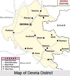
 Deoria District is one of the administrative districts of Uttar Pradesh and it forms a part of Gorakhpur Division. Deoria District is located between 26 degree 6 minutes north and 27 degree 8 minutes to 83 degree 29 minutes east and 84 degree 26 minutes east longitude. Deoria District is surrounded by district Kushinagar in the north, district Gopalganj and Siwan (Bihar) in the east, district Mau and Ballia District in its south and by district Gorakhpur in the west. Deoria, district headquarter, is situated at 53 kms milestone from Gorakhpur by road towards east. Bhojpuri language is the language commonly used in the district.
History of Deoria District
Deoria District came into being on March 16th, 1946. Initially it was a part of Gorakhpur District. As per the official gazettes, the district name was derived from the district headquarters `Deoria`. Deoria District played a significant part in the freedom struggle of the country.
Geography of Deoria District
Ghaghara River, Rapti and Chhoti Gandak are the main rivers in this district. Besides these, Gorra, Bathua, Kurna, Majhne and Nakta are some of the small rivers that originate from these major rivers. Climate of this district is moderate. May and June are the hottest months and December and January are the coldest months of the year. Soils of different types are found in the district. Domat, Bhat, Matiyar and Balui Domat are commonly found.
Administration of Deoria District
 Administration of Deoria District is headed by District Magistrate or District Collector. For better administration, the district is divided into Sub-Divisions or Tehsils. Deoria District is divided into five sub-divisions or tehsils namely Deoria sadar, Salempur, Rudrapur, Berhaj and BhatparRani. Each Sub-Division is headed by a Sub Divisional Magistrate or Tehsildar.
Economy of Deoria District
Economy of Deoria District is agrarian in character. Agriculture is the main business of the people of Deoria District. Land of the district is plain and fertile whose slope is towards south-east from north. Soil of north region is mainly Bhat type, middle region is mainly Domat type and south region is mainly Balui Domat type. Middle portion of the district is quite fertile and is called `bangar`. Rabi crop consists mainly of Wheat, Gram, Mustard, etc. Kharif crop consists mainly Rice, Maize, Arhar etc. Sugarcane is the major cash-crop of the district.
Tourism in Deoria District
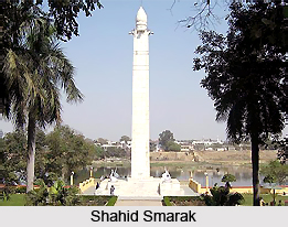
There are several places of interest in Deoria District. Some of the main attractions of this district are Shahid Smarak, Ramlilala Maidan, Hanuman Mandir, Somnath Mandir, Deorahi Mandir, Dugdheswarnath Mandir, Dirgheswar Mandir and Parshuram Dham. Tourism in Deoria District includes visits to several religious and historical sites. All these tourist spots offered by Deoria District are worth visiting.
Culture of Deoria District is diverse and rich. Several fairs are organised here on different festivals.


