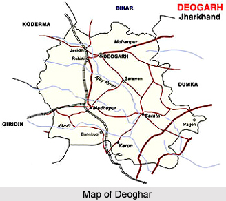
 Deoghar Distirct is located in the state of Jharkhand in the Eastern part of India, and is among the twenty four district of the state. The Deoghar Town is the administrative headquarter of the district. This district is also known as Baidyanath Jyotirlinga shrine, and happens to be a part of Santhal Pargana division. The district experience hot summer (March to May) heavy monsoon rains (June to September) and cool dry winters (October to February). The district comprises seven blocks: Madhupur, Mohanpur, Deoghar, Karon, Palojori, Sarath and Sarwan. There are 3 Vidhan Sabha constituencies in Deoghar district: Sarath, Madhupur and Deoghar.
History of Deoghar Distirct
The Deoghar District was formed on 1st June 1986 by separating Deoghar sub-division of the former Santhal Parganas District.
Geography of Deoghar District
The district is situated in the western part of Santhal Parganas and is bordered by Bhagalpur District in the north, Dumka in East and South and in the West by Giridhi District. The district extends from 86 degree and 28 minutes and 87 degree and 04 minutes East longitude and 24 degree and 03 minutes and 23 degree and 38 minutes North latitude. It comprises 2481 km2 area.
The district had several clusters of rocky hills covered with forests and series of long ridges with intervening depressions. Most parts of the rolling uplands are cultivated by highland crops.
Demography of Deoghar District
According to the Population Census in 2011, Deoghar District had a population of 1,491,879 of which male and female were 776,741 and 715,138 respectively. The population of Deoghar District constituted 4.53 percent of total population of Deoghar District. The population density of Deoghar district for 2011 is 602 people per sq. km. Deoghar district administers 2,479 square kilometers of areas. The average literacy rate of Deoghar in 2011 was 66.34 percent compared to 50.09 of 2001. If things are looked out at gender wise, male and female literacy were 79.13 percent and 52.39 percent respectively. The total literates in Deoghar District were 815,303 of which male and female were 507,373 and 307,942 respectively.
Culture of Deoghar District
Deoghar District is a popular place for tourists. And tourists from all over India throng the place in the month of Sawaan month (July, August) to worship Lord Shiva. Trikut Parvat, Nandan Pahar and Pagal Baba Aasram and lots of place for enjoyment. The place also has a beautiful, serene and mind blowing park called Jalsar Park located in the centre of the city.
Education of Deoghar District
One of the main colleges in the area is Deoghar College that was founded in the year 1951 and is one of the constituent colleges of Sido Kanhu Murmu University at Dumka. Rama Krishna Mission Vidyapith, Deoghar was founded in 1922 and is known for its high quality education in secondary and higher secondary levels. It is also known as Bangla Vidyapith among the locals. This school is run and managed by Rama Krishna Ashram, Belur Math, Kolkata.
Tourism in Deoghar District
The Saawan Mela is a special attraction for people as well. There are many temples in and around Deoghar District. Some of them are Ajgaibinath, Deva Sangha Math, Dolmanch, Harila Jori, Baiju Temple, Basukinath, Hathi Pahar or Mahadevatari, Jain Temple, Lila Temple, Shitala Temple, Shivaganga, Mansarovar, Tapovan, Tarapith Temple, Kathikund, Kundeshwari, Nandan Pahar, Naulakha Temple, Rikhia Ashram, Pagla Baba Ashram, Ram Krishna Mission Vidyapeeth, Satsang Nagar & Ashram, Trikuta Parvata.


