Home > Indian History > Geography of India > Delhi Metro
Delhi Metro
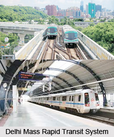
Delhi Metro which is also known as Delhi Mass Rapid Transit System is the redefined form of public transportation in Delhi.

Share this Article:

Delhi MetroDelhi Metro has redefined Delhi transportation system and also the urban life of Delhi. It is one of the major contributions in Delhi from Metro Railways in India for carrying smooth life.

Concept of Delhi Rapid Transit
The concept of a mass rapid transit for New Delhi first materialized from a traffic and travel characteristics study. It was carried out in Delhi in 1969. Over the next several years, many official committees by a variety of government departments were commissioned to study the issues related to technology, route alignment and governmental jurisdiction. In 1984, the Delhi Development Authority and the Urban Arts Commission came up with a proposal for developing a multi-modal transport system, which would consist of constructing three underground mass rapid transit corridors as well augmenting the city`s existing suburban railway and road transport networks.

Operation of Delhi Metro
Delhi Metro operates from the national capital of India, Delhi and is under the supervision of the Delhi Metro Rail Corporation Limited (DMRC). DMRC is an Indian corporation that was formed on March 5, 1995. The Delhi Metro was launched on December 24, 2002 and became the second underground rail system in India after the one in operation in Kolkata.

Network of Delhi Metro
Delhi Metro is India`s first modern civic transportation system, which has revolutionized travel by providing a swift, dependable, secure and cosy means of transport. This network consists of six lines with a total length of 189.63 kilometres (117.83 mi) with 142 stations of which 35 are underground, five are at-grade and rest are elevated. The Delhi Metro has a blend of prominent, up-grade and underground tracks.

Speed of Delhi Metro
The trains travel at a speed below 80 km/hr. and stop for 20 seconds at each station. The train service operates from six in the morning till eleven at night. A single train consists of four coaches and can carry up to 240 seated and 400 standing passengers. All the trains have air-conditioned coaches loaded at a temperature of 20-22 degree Celsius.

Delhi Metro Police
A new department Delhi Metro Police has been set up that exclusively looks after the law and order inside the Metro. Metro police is present in every station for the security of the passengers. High end close circuit camera monitors all the stations. Emergency communication system is also provided between the passengers and the driver in every coach.

Service Offered by Delhi Metro
The stations of Delhi Metro have Automated Teller Machines (ATM), food outlets, cafes and convenience stores. The ticket facilities are divided into three categories -Smart card, Tourist card and token. The Metro stations of Delhi have been decorated with murals by local art college students.


Share this Article:

Related Articles

More Articles in Geography of India


Geography of Uttar Pradesh
The fourth largest State in India UP is located in the Northern part of India whose area is 2,36,286 sq Kms.
Geography of Maharashtra
Covering an area of 308,000 sq. km, Maharashtra, the third largest state in India.
Geography of Kerala
Geography of Kerala includes plains, hills, valleys and coasts. With the Arabian Sea in the west, the Western Ghats in the east and networked by several rivers, Kerala enjoys diverse geographical features.
Geography of West Bengal
The geography of West Bengal is unique with high peaks of the Himalayan range in the north, the Bay of Bengal in the south and the remaining region is covered with both plains and plateaus.
Geography of Jharkhand
Geography of Jharkhand is comprised of the rich mineral resources and the highly agricultural prospect in this state.
Geography of Sikkim
Geography of Sikkim is characterised by a vast array of magnificent hillock that extends from one corner of the state to the other.
Geography of Meghalaya
The suitable climate, highland plateaus, rivers and the flora and fauna together forms the geography of Meghalaya.
Geography of Mizoram
Mizoram is surrounded by hills, valleys, rivers, waterfalls and lakes. The hills range from 1000 meters to 2000 meters. Rivers, lakes and waterfalls also play major role in forming the land of Mizoram.
Geography of Jammu & Kashmir
Jammu and Kashmir is encompassed by valleys. Some of the dominant valleys of the state are Kashmir Valley, Tawi Valley, Chenab Valley, Poonch Valley, Sind Valley and Lidder Valley etc. Jhelum River is the only major Himalayan River which flows through the Kashmir valley. Indus, Tawi, Ravi and Chenab Rivers are the major ones flowing through the region.
Geography of Daman and Diu
Daman and Diu is situated on the west coast of India and are the smallest union territories of India.
Geography of Goa
Geography of Goa occupies a prime location along the Konkan coastal belt on the western coast of India. The state is bordered by Maharashtra in the north and Karnataka in the south. The Western Ghats in the east contribute to the flora and fauna of Goa.
Geography of Arunachal Pradesh
Geography of Arunachal Pradesh reveals that it is a hilly tract nestled in the foot of Himalayas.
Geography of Kutch
Geography of Kutch District is covering an area of 45,612 km. Kutch District is the largest district in the state of Gujarat.
Geography of Ladakh
Geography of Ladakh mainly comprises the huge Karakoram Range with long stretch of cold desert which mark the region separately from the rest of the states of Indian subcontinent. Surrounded with the mountain ranges from all corners this small region separates Indian subcontinent from rest of the Asian continent.
Geography of Rajasthan
Geography of Rajasthan defines the dry topography with arid climate of the western mountain region.
Geography of Tamil Nadu
The Indian state of Tamil Nadu is located in the Northern hemisphere in the hot zone.