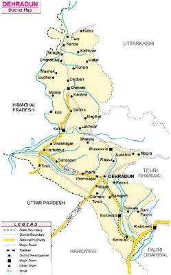
 Dehradun District is situated in the north-west corner of Uttarakhand. Dehradun is the district administrative headquarters. Nestled in the mountain ranges of the Himalaya, Dehradun is one of the oldest cities of India. Also known as the `Abode of Drona`, Dehradun has always been an important centre for Garhwal rulers, which was captured by the British government. Total area of the district is 3088 sq kms and its average altitude is 640 metres (2100 ft) above sea level. Main languages spoken in the district are Hindi Language, Sindhi Language, Punjabi Language, Garhwali Language and Urdu Language.
Location of Dehradun District
Dehradun District lies between 29 degrees 58 minutes and 31 degrees 2 minutes 30 seconds north latitudes and 77 degrees 34 minutes 45 seconds and 78 degrees 18 minutes 30 seconds east longitudes. Dehradun District is bounded on the north and to some distance in the north-west by the district of Uttarkashi, in the east by the districts of Tehri Garhwal and Pauri-Garhwal, in the south by Saharanpur District of Uttar Pradesh, and its southern tip touches the boundary of Haridwar District. The western boundary of Dehradun District adjoins the Sirmaur District of Himachal Pradesh with Tons River and Yamuna River separating the two.
 History of Dehradun District
According to Skanda Purana, Dun formed part of the region called Kedar Khand. It was included in the kingdom of Ashoka by the end of the 3rd century B.C. It is revealed by the history that for centuries the region formed part of Garhwal kingdom with some interruption from Rohillas. For about two decades till 1815 it was under the occupation of the Gurkhas. In April 1815, Gorkhas were ousted from Garhwal region and Garhwal was annexed by the British. In that year, the area now comprising tehsil Dehradun was added to district Saharanpur. In 1825, however, it was transferred to the Kumaon Division. In 1828, Dehradun and Jaunsar Bhabar were placed under the charge of a separate Deputy Commissioner and in 1829 Dehradun district was transferred from Kumaon Division to Meerut Division. In 1842, Dun was attached to Saharanpur District and placed under an officer subordinate to the Collector of the district but since 1871 it is being administered as a separate district. In 1968, the district was taken out from Meerut division and included in Garhwal Division.
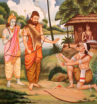
The district is named after its chief city Dehradun. Dehra appears to be a corruption of dera signifying a temporary abode or camp. The term dun or doon means the low lands at the foot of a mountain range, and as the bulk of the district lies in such a terrain, it justified the dun part of the name. Another derivation of the term dun is stated to be from Dron Ashram, hermitage of Guru Dronacharya of Mahabharata, who sojourned for a season in the village of Devara, situated near to Dehra to perform his devotions at a lonely spot.
Geography of Dehradun District
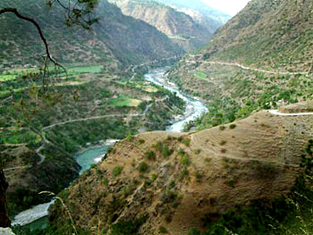
 Geography of Dehradun District generally comprises hilly terrains. Forest areas cover a major portion of the total area of the district. Forest products constitute a significant portion of the economy of the district. Chir is the only coniferous species in the old reserved forests of Dehradun. Besides other associates of chir, a few deodar trees are also seen in the district. Wide ranges of Sal forest occur in this part of the tehsil. Sal is the main timber species and is mainly found towards the Shivalik ridges. Mixtures of miscellaneous species are found in the lower parts. Yamuna River, Tons River and Ganga River are the main rivers flowing through the district.
Administration of Dehradun District
Dehradun District, at present comprises six Tehsils, namely Dehradun, Chakrata, Vikasnagar, Kalsi, Tyuni and Rishikesh. There are six Community Development blocks in Dehradun District namely, Chakrata, Kalsi, Vikasnagar, Sahaspur, Raipur and Doiwala. Further, it has 17 towns and 764 villages (746 inhabited and 18 uninhabited).
Economy of Dehradun District
Agriculture forms the base of economy of Dehradun District. Several seasonal crops are cultivated in the district. Like for instance, rice, wheat, maize, sugarcane, arhar, Mustard, etc. are some of the main crops cultivated in the district. Tourism industry and several small scale industries also contribute to the economy of Dehradun District.
Tourism in Dehradun District
Dehradun District is a favoured tourist destination as it attracts tourists, pilgrims and enthusiasts from various walks of life to its serene environs. Add to this the abundance of special Basmati rice, tea and leechi gardens which contribute in turning the city into a paradise. There are several tourist attractions in Dehradun District. Some of the major ones include Tapkeshwar Temple, Sahastradhara, Dakpathar, Asan Barrage, Laxman Sidh, Malsi Deer Park, Chandrabani, Sai Darbar, Tibetan Temple, and Robber`s Cave, Tapovan, Rajaji National Park and many more.
The headquarters of many National Institutes and Organizations like ONGC, Forest Research Institute, Indian Institute of Petroleum etc are located in the city. Some of the premier educational and Training Institutes like Indian Miltary Academy, RIMC (Rashtriya Indian Military College), Indira Gandhi National Forest Academy (IGNFA), Lal Bahadur Shastri National Academy of Administration (LBSNAA) etc are also there in Dehradun. Dehradun District is well served by roads and to some extent by rails. Dehradun and Rishikesh are the two railway terminals of the northern railway.


