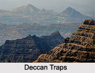
 Deccan Traps of India create a huge igneous province, which is located on the Deccan Plateau of west-central part of the country. This province has the distinction of being one of the largest volcanic provinces in the world. The term traps has been derived from a Scandinavian word `trappa` meaning stairs. Traps relates to step-like hills present in west-central India.
Origin of Deccan Traps of India
Deccan Traps of India are known to be formed 60 to 68 million years ago at the end of the Cretaceous period. Various studies depict various reasons for the origin of Deccan Traps. It was assumed that the Deccan Traps eruption was associated with a deep mantle plume, but the mantle plume model has been questioned. The Reunion hotspot, which is an area of long-term- eruption is assumed to trigger Deccan Traps eruption and opening the rift that once resulted in the division of Seychelles plateau and India. Studies have found strong correlations between the movement of the Indian tectonic plate and the eruptions of the Deccan Traps. There are studies which support the connection between the Deccan Traps eruption and the asteroid effect which resulted in the creation of the Chicxulub Crater in the Mexican state of Yucatan. It is important to note that erosion and continental drift resulted in the region of the Deccan Traps to be reduced to its current size. 
Composition of Deccan Traps of India
Deccan Traps of India are solidified flood basalts. They are made up of more than 6,600 feet of flat-lying basalt lava flows, covering an area of nearly 200,000 square miles. The basalt has a volume of about 122,750 cubic miles. The flood basalts are reminiscent of the Columbia River basalts of the northwestern United States. The thickness of the Deccan Traps is highest on the Western Ghat range or in the fault-bounded grabens in west-central India. The Deccan Traps become thinner close to the edge of the trap province. About 95 percent of the lavas within the Deccan Traps are tholeiitic basalts. The other rock types are alkali basalts, nephenlinites, lamprophyre and carbonatites. The layers of lava in the Deccan Traps contain beds of fossils. They have made Deccan Traps popular. Mantle xenoliths have also been recorded in a few places of the Deccan Traps.
Effect of the Origin of Deccan Traps of India
Volcanic eruption occurred in the Western Ghats some 66 million years ago. The resultant origin of the Deccan Traps triggered the release of volcanic gases like sulphur dioxide. These volcanic gases are considered to be the cause behind contemporary climate change and global warming. It was estimated that during the time of the formation of the Deccan Traps, there was an average drop in temperature of about 2 degree Celsius.


