 Datia is the District headquarters of the Datia District. The town Datia is situated in the Datia District, which is 69 Kilometers from Gwalior and 325 Kilometers South of New Delhi and 320 Kilometers North of Bhopal.
History of Datia District
Datia district is is an ancient district mentioned in Indian Epic, Mahabharata as Daityavakra. Datia District had formerly been a state in the Bundelkhand region. The Rajputs of the Bundela clan ruled Datia District. They are descended from a younger son of a former Raja of Orchha. The state was administered as part of the Bundelkhand agency of Central India. It lay in the extreme north-west of Bundelkhand, near Gwalior, and was surrounded on all sides by other princely states of Central India, except on the east where it bordered upon the United Provinces.
After the independence of India in 1947, the Maharaja of Datia ascended unto the dominion of India. It later merged with the Union of India. Datia, together with the rest of the Bundelkhand agency, became part of the new state of Vindhya Pradesh in 1950. In 1956, Vindhya Pradesh state was merged with certain other areas to form the state of Madhya Pradesh within the Union of India.
Geography of Datia District
The district of Datia has an area of 2,038 square kilometers. Each town of the Datia District is the headquarters of its tehsil. Datia is bounded by the Madhya Pradesh districts of Bhind to the north, Gwalior to the west, and Shivpuri to the south, and by Jhansi District of Uttar Pradesh state to the east. The district is part of Gwalior Division.
Demography of Datia District
In 2011, the census data of India reveals that Datia had population of 786,375. Out of which male and female were 419,432 and 366,943 respectively. The density of Datia district for 2011 is 292 people per square. Kilometers.
The average literacy rate of Datia in 2011 was 73.50 percent. The total literate in Datia District were 497,883 of which male and female were 307,131 and 190,752 respectively.
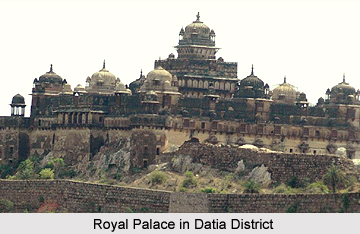
Tourist Attraction Sites in Datia District
The "Purana Mahal" or "Datia Mahal"is one of the most important tourist attraction sites. It was built to welcome one of the greatest Mughal Emperors of India, King Jahangir after his coronation but the Emperor never came in this District. The town Datia is a market centre for food grains and cotton products. In Datia District, the handloom weaving is an important industry. It is famous for the seven-storied palace built by Raja Beer Singh Deo in 1614.
It is also the pilgrimage spot for devotees; Datia has the Sidhapeeth of Shri Peetambhara Devi, Buglamukhi Devi Temple and Gopeshwar temple. About 15 Kilometers from Datia is the Sonagiri. In that place, there are a huge number of temples called Sona giri temples.It is a scared Jain hill. Datia is 34 kilometers from Jhansi, Uttar Pradesh and 52 Km from the priencely state of Orchha. Vankhandeshwar temple is an ancient temple in Datia district built during the time of Mahabharata. The temple of Lord Shiva is situated at this place. Pitambra Peeth is about 1 kilometers from Datia Bus Station and 3 Kilometers from Datia Railway Station
The nearest airport to reach the Datia District is at Gwalior. Datia railway station is on the Delhi-Chennai main line. The Peetambra peeth is a famous shaktipitha located at the entrance of Datia in Madhya Pradesh. This pilgrimage spot features Buglamukhi Devi Temple and Dhumavati Mai Temple established by Shri Golokwasi Swamiji Maharaj.


