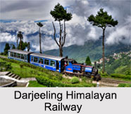
 Darjeeling Himalayan Railway is the first and is still the most exceptional example of a hill passenger Railway. It is also considered as a UNESCO World Heritage Site, declared in 1999. This is the second railway to have this honour bestowed upon it, after the Semmering Railway of Austria in 1998. The railways are run by the steam engines, still in service in India. The railway connects the town Darjeeling with the plains.
History Of Darjeeling Himalayan Railway
Darjeeling Himalayan Railway was built between 1879 and 1881 and is approximately 86 kilometres long. It was an agent of the Eastern Bengal Railway Franklin Prestage who approached the government with a proposal to lay a steam tramway from Siliguri to Darjeeling. The application was accepted in 1879 after an encouraging report by the committee and construction began that year.
Gillander Arbuthnot constructed the railway and the stretch from Siliguri to Kurseong was opened on 23rd August 1880, while the authorised opening of the line up to Darjeeling was done on 4th July 1881. Several engineering adjustments were made later in order to relieve the slope of the rails. In spite of natural calamities such as an earthquake in 1897 and a major cyclone in 1899, the Darjeeling Himalayan Railway continued to improve with new additional lines, and the passenger as well as goods carrying was increasing gradually. Darjeeling Himalayan Railway started to face competition from bus services that started operating along the Hill Cart Road, and took less time than the railway to reach Darjeeling. Darjeeling Himalayan Railway played a vital role in transporting military personnel and supplies to the numerous camps around Ghoom and Darjeeling, during World War 2.
After the independence of India, Darjeeling Himalayan Railway was included in the management of Indian Railway, and became a part of the Northeast Frontier Railway zone in 1958. In 1962, the line was once again aligned at Siliguri and extended by nearly 4 miles (6 km) to New Jalpaiguri (NJP) to meet the new broad gauge line there. Darjeeling Himalayan Railway remained closed for 18 months during the antagonistic period of Gorkhaland Movement in 1988-1989. The railway was extended to the south in 1964 to convene the new Broad gauge to Assam. Siliguri Junction became a major station when a new meter-gauge line was built to Assam in the early 1950s.
Operators Of Darjeeling Himalayan Railway
Darjeeling Himalayan Railway is owned by the government of India and commended to the Ministry of Railways. The Northeast Frontier Railway documented the railway in an inclusive register and handles its everyday preservation and management.
Route Of Darjeeling Himalayan Railway
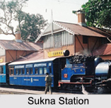
Darjeeling Himalayan Railway follows Hill Cart Road, which is a part of National Highway 110. Stations of Darjeeling Himalayan Railway route are New Jalpaiguri, Siliguri Town, Siliguri Junction, Sukna, Rongtong, Tindharia, Loop 4, Reverse Number 6, Kurseong, Tung, Sonada, Rangbul, Jorebungalow, Ghum, Batasia Loop and Darjeeling.
Darjeeling Himalayan Railway In Present Days
All the steam locomotives of Darjeeling Himalayan Railway currently in use on the railway are of the `B` Class, this design was built between 1889 and 1925. A total of 34 were built but by 2005 only 12 remained on the railway and in use and under repair. Locomotive number 787 has been rebuilt with oil firing. This was originally installed to work on the same principle as that used on Nilgiri Mountain Railway. To operate the oil burner and an electrically driven feed pump, a diesel-powered generator was fitted and to aid the braking system, a diesel-powered compressor was also fitted. Additionally the locomotive of Darjeeling Himalayan Railway was fitted with a feed water heater that resulted in a dramatic change in the appearance of the locomotive.
Several Bollywood movies have portrayed the Darjeeling Himalayan Railway. Especially popular was the song `Mere sapno ki rani` from the film "Aradhana". Other notable films, where the Darjeeling Toy Train was shown include "Jhumroo", "Parineeta", "Main Hoo Na" and "Raju Ban Gaya Gentleman". The BBC made a series of three documentaries on the mountain railways of India, which was first broadcast in February 2010 where it covered the Darjeeling Himalayan Railway at first.


