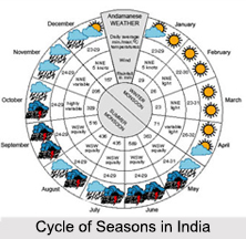
 Cycle of Seasons in India is a magical occurring of the nature that changes the colour and charm of the environment in passing months. The climatic conditions of India can best be delineated in terms of a yearly cycle of seasons. The intensity of each of the Cycle of Seasons in India varies from region to region depending upon the topographical factors, latitude and longitude of the region. The various Cycle of Seasons India experiences throughout the year are broadly classified as Cold Weather, Hot Weather, Advancing Monsoon and Retreating Monsoon. These classifications are made keeping in mind the changes in temperature, air pressure, topography, amount of rainfall, changes in directions and intensity of air current.
Cold Weather in Cycle of Season
The Cold Weather in India refers to winter in the country. Once the monsoons subside, average temperatures eventually fall across India. The temperatures change by about 0.6 degree Celsius per degree of latitude. December and January are the coldest months, with mean temperatures of 10-15 degree Celsius in Indian Himalayas. In north-western India, almost cloudless conditions prevail in October and November. Heavy snowfall is experienced in Jammu and Kashmir. Blizzards occur regularly, disrupting travel and other activities. The rest of north India, including the Indo-Gangetic Plain, almost never receives snow. In south India, particularly the hinterland of Maharashtra, Madhya Pradesh, parts of Karnataka and Andhra Pradesh, somewhat cooler weather prevails (around 10 degree Celsius).
Hot Weather in Cycle of Season
The Hot Weather in India in the Cycle of Seasons refers to the summer that usually lasts in north-western India from April to July, and in the rest of the country from March to June. The temperature in the north rises as the perpendicular rays of the sun reaches the Tropic of Cancer. The hottest month in the Cycle of Seasons for the western and southern regions of the country is either April or May. Temperatures of 50 degree Celsius and higher have been recorded in parts of India during this season. In cooler regions of north India, temperatures are moderate. Near the coast, temperature hovers around 36 degree Celsius and the proximity to the sea increases the level of humidity.
Advancing Monsoon in Cycle of Season
The Advancing Monsoon in the Cycle of Seasons last for a four-month period, when massive convective thunderstorms dominate India`s weather. More specifically, the southwest monsoon arrives in India that even in two branches namely, the Bay of Bengal branch and the Arabian Sea branch. The monsoon typically breaks over the Indian Territory around 25th of May, when it lashes the Andaman and Nicobar Islands in the Bay of Bengal. It strikes the Indian mainland around 1st of June, close to the Malabar Coast of Kerala. However, north-east India receives the most precipitation. By the end of November, monsoons leave the country. The rains reduce temperatures and refill groundwater tables, rivers and lakes.
Retreating Monsoon in Cycle of Season
The Retreating Monsoon in the Cycle of Seasons lasts from the month of October to the month of December. The northeast or retreating monsoon brings dry, cool and dense Central Asian air masses to large parts of India. Wind spills across the Himalayas and flows to the southwest across the country, thus bringing in clear and sunny skies. Average daily maximum temperatures during this time range between 28 degree Celsius and 34 degree Celsius. The north-east monsoon, which begins in September, lasts through the post-monsoon seasons and only ends in March.
So, these are the Cycle of Seasons in India as classified by the meteorological department. The span and intensity of these seasons are not fixed and are subject to change depending upon certain external environmental factors such as air pressure, direction of air currents, cloud formation, anthropological factors such as deforestation and pollution, etc.


