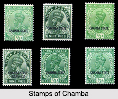
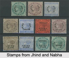
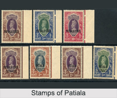
 During the reign of the British East India Company, the Post Office of India or the Indian Postal Service had entered into postal conventions with few of the native states of India. As per these postal conventions or agreement, the existing adhesive stamps and postal stationery provided by the British India were overprinted with the names of the respective Convention States.
These stamps were issued for mail for one Convention State to another and to other destinations within the territory of British India. The function of the state administrators was to conform to a number of agreements covering the issuance of stamps, the rates of postage and the exchange of mail. The stamps of the convention states all became invalid on 1st January 1951, when they were replaced by the stamps of the independent Republic of India, valid from 1st January, 1950.
Convention States of India
Under the British Government, there were almost 625 Princely States, and most of them did not use postage stamps. With two types of stamp issuing states, the postage stamps and postal histories of these states provide a record for about 6 Princely States to be a part of the Convention States. The first Convention State was Patiala, in 1884, followed by others in 1885. Discussed elaborately below are the Convention States of India:
 Chamba: The princely state of Chamba was located in the Himalayas, currently in the state of Himachal Pradesh in northern India. The state used to be under the control of the British Government of Punjab. This rural hill state was situated between the territories of Kashmir and the Punjab districts of Kangra and Gurdaspur.
The state of Chamba had a postal convention with British India from 1887 onwards and issued stamps till 1947. The state issued a total of 120 stamps and 86 official stamps from 1885 till 15th April, 1948 when it became part of Himachal Pradesh. Currently, these convention state stamps of Chamba can be viewed at the Bhuri Singh Museum of the state and the Postal Museum in Canada.
Faridkot: Known to be the smallest of all the Punjabi convention states, Faridkot was the second princely state to sign a postal convention with the Indian Postal Service. From 1763 onwards, the state was ruled by a Sikh dynasty and the ruler at the time of the postal convention was Raja Bikram Singh.
For almost a decade from 1879 to January 1887, Faridkot used to be a Feudatory State and had issued stamps independently, when it signed a postal convention. From 1887 onwards, it became a Convention State and issued 17 stamps and 15 official stamps but ceased to use overprinted stamps after 31st March, 1901. Consequently, all Faridkot stamps bear the bust of Queen Victoria and had the shortest period of issue. Compared to any other Convention State, Faridkot issued the fewer amounts of stamps.
Gwalior: Located in Central India, Gwalior was one of the largest princely states of that region. The state had signed a postal convention on 1st July, 1885 and possessed an efficient postal system with its headquarters at the capital city of Lashkar, present day Gwalior city.
 Initially, the state of Gwalior used the postage stamps of British India overprinted at the Government of India Central Printing Press, Calcutta till 1926 and later at the Security Press in Nashik. Gwalior issued a total of 137 stamps and 94 official stamps from 1885 till 1949. Like the other stamps of the Convention States, the stamps issued by Gwalior also had a rich collection of varieties and errors.
Jhind: A fragmented Phulkian state comprising of three main enclaves and some isolated villages, the state of Jhind signed the postal convention on 1st July, 1885. The Sikh ruler of Jhind, Raja Ranbir Singh was a minor at the time of signing of the postal convention and the state was ruled by a Council of Regency at that point in time.
Prior to being a Convention State, Jhind issued stamps as a Feudatory State from 1864 to 1885. And later as a Convention State, Jhind issued a total of 149 stamps and 86 official stamps from 1885 till 20th Aug 1948 when it was absorbed into the Patiala and East Punjab states union. Over the years, the overprint on the stamps of Jhind has been spelled differently starting from "JIND", "JHIND", "JEEND" and "JEIND".
Nabha: Also part of the Phulkian lineage, the princely state of Nabha at the time of signing the postal convention was under the rule of Raja Hira Singh (1843 to 1911). Though Nabha was a rural state, it maintained 15 post offices, which was controlled by a postmaster general and connected main lines. Nabha issued a total of 117 stamps and 68 official stamps from 1885 till 20th Aug 1948 when it was absorbed into the Patiala and East Punjab states union.
Patiala: One of the largest, wealthiest and most populous of the Phulkian states, Patiala was the first of the Phulkian states to sign a postal convention on 1st October 1884. At the time of the signing of the convention, the ruler Maharaja Rajendra Singh was a minor and the state was administered by a Council of Regency.
A telegraph line from Ambala to Patiala was constructed by the British Government at the expense of the state. The line was constructed under an earlier agreement conducted in 1872 and was maintained by the state.
Convention States Philately
With a relatively small scope of stamps and a large variety of errors and changes in printing settings for different batches provide adequate scope for philately. The Convention States philately is an obscure branch of classical Indian philately.
The stamps of the Convention states are a part of classical philately as they are plain, unembellished, produced to order for bona fide use and under conditions strictly- controlled by the British Government. The Indian convention state philately faces problems of forgeries, especially in high values and errors due to the overprinting on British Indian stamps of the period.


