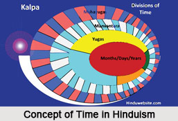
 Concept of time in Hindu astronomy is one of the earliest innovations. While the division of time in the Vedic period mainly included the division of day and night, seasons, months, intercalary months and the lunar and solar calendars which was calculated according to the position of the sun and the moon. This got changed and verified with the new calculations which were introduced with the innovation of Mathematics, geometry and algebra as introduced by Aryabhata I and other astronomers. Overall time in Hindu astronomy includes the position of Sun and moon and the longitudinal as well as latitudinal position of the earth which can be calculated with Aryabhatan method of calculations along with the other astronomical instruments.
Concept of time in Hindu astronomy has developed through a long period while initially it was calculated with the position off the Sun and its reflection on the shadow which could be calculated through the astronomical instruments. This was further developed with the growth of astronomical theories which now included the longitudinal position of the Earth; latitude and the Zenith distance; the ascesional difference and its impact on the calculation of Ahargana. It was during the Surya Siddhanta when the ancient method of calculating time went through some metamorphosis. With the mathematical innovations introduced by Aryabhata I, the method of calculating time became more scientific and accurate. It was now observed that time in the earth also depended on the spherical shape of the Earth and its latitudinal position along with longitudinal position which not only decided the time but also the direction and the place.
Concept of time in Hindu astronomy received maximum impetus within the Modern Surya Siddhanta . Surya Siddhanta was the first Siddhanta which developed with ages and for the first time provided a comprehensive knowledge regarding the position of the Earth, Sun Moon and other planets who revolve round the sun and its impact in calculating time. The mathematical calculations began with innovations of Aryabhata I which was later on composed in a more composed form Latadeva which included matters like Mean motions of the planets (madhyamddhikdra) True places of the planets (spastddhikdra), Determination of direction, place and time (triprasnddhikara), Lunar eclipse (candragrahanddhikdra), Solar eclipse (suryagrahanddhikdra), parallax, Projection of eclipses (chedyakddhikdra), Planetary conjunctions (grahayutyadhikara), Conjunction of planets with junction-stars of naksatras(naksatragrahayutyadhikara), Heliacal risings and settings of planets (udaya-stadhikara), Moon`s risings and settings and the elevation of the moon`s horns (srngonnatyadhikara), Phenomena called (patadhikara), Cosmogony and geography (bhugolddhyaya) ,Astronomical instruments (jyotisopanisadadhyaya) and Reckoning of time (manadhydya).
 Concept of time in Hindu astronomy under modern Surya siddhanta further included the concept of equinox which would calculate equal day and equal night - a position when the sun stands completely northwardly or southwardly that divides the earth into two equal halves and the time accordingly. This appears twice the year. These innovations were further rechecked by astronomers of later period like Paramesvara and Nilkanta Soyamji and others in due course of time. Surya siddhanta in ancient Hindu astronomy gave a set of rules which were vital for calculating time. This claimed that while the planets have a usual motion of revolution from east to west which they complete in a day, it is crossed by the rotation of the asterism which are supposed to move from the west to east in the process clashes with each other. This brings the fact that the earth has its own motion and direction which decides the time of the earth. Further Surya Siddhanta lays down the formula which can calculate the completion of a year with the longitudinal position of the Earth and its complete rotation around the sun. This shall further decide the number of civil days in an ahargana.
Thus Time in Hindu astronomy became one of the most important concepts which required verifications from time to time. With the growth of science and mathematics in calculating the rotation of the earth the process of calculating time turned to be more accurate and significant.


