Home > Indian History > Geography of India > Cinque Island
Cinque Island
Cinque Island is a part of Wandoor Marine National Park which is also known as Gandhi Marine National Park, is a famous tourist attraction site, located in Andaman and Nicobar Islands.

Share this Article:

Cinque Island, Andaman and Nicobar Islands
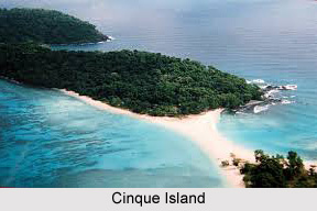
Cinque Island is an island of natural beauty of dense jungle with spectacular looks. Now Cinque Island is a part of Mahatma Gandhi Marine National Park which is popularly known as Wandoor Marine National Park. Cinque Islands are a pair of islands in the Andaman Archipelago, on the north side of Duncan Passage, between Rutland Island and Passage Island.

Cinque Island is situated 26 kilometers from Port Blair. This island is accessible through almost all major islands by boat. However, no scheduled ferry services are available for the place. One will have to hire a chartered boat of permitted category. Visiting the Cinque Island requires permission from the Forest Department of Andaman and Nicobar Islands which can be availed without much hassle.

Cinque Island is a remote isle belonging to the Union Territory of Andaman and Nicobar Islands. Cinque Island is a popular tourist destination in the Andaman and Nicobar Islands. This solitary island is best known for its underwater coral gardens and rich marine life, which allures scuba diving among the tourists of both national and international arena.

Cinque Island is divided into North Cinque Island and South Cinque Island which are connected together by a sandbar giving the whole island a spectacular look. North Cinque Island and the South Cinque Island are about 1 kilometre to the south. These islands are sometimes considered to be a single Cinque Island. The passage between North Cinque and Rutland is called Manners Strait. It is a part of Mahatma Gandhi Marine National Park (popularly known as Wandoor Marine National Park) along with 15 other islands and islets of the Labyrinthine Island Group in Andaman and Nicobar Isles. Cinque Island has absolutely no human habitation but is amazingly rich in flora and fauna making it an ideal place for eco- tourism among the tourists in national and international hemispheres.

Cinque Island was declared as a sanctuary. And this island is the abode of enormous variety of coral reefs, sea weeds, colourful fishes, shells, starfish, sea anemones, salt-water crocodile, turtles and water snakes.

Cinque Island is bounded by coral reef gardens that extend to a few hundred meters into the deep sea. Also, it offers activities like scuba diving, snorkelling, game fishing and camping.


Share this Article:

Related Articles

More Articles in Geography of India


Geography of Uttar Pradesh
The fourth largest State in India UP is located in the Northern part of India whose area is 2,36,286 sq Kms.
Geography of Maharashtra
Covering an area of 308,000 sq. km, Maharashtra, the third largest state in India.
Geography of Kerala
Geography of Kerala includes plains, hills, valleys and coasts. With the Arabian Sea in the west, the Western Ghats in the east and networked by several rivers, Kerala enjoys diverse geographical features.
Geography of West Bengal
The geography of West Bengal is unique with high peaks of the Himalayan range in the north, the Bay of Bengal in the south and the remaining region is covered with both plains and plateaus.
Geography of Jharkhand
Geography of Jharkhand is comprised of the rich mineral resources and the highly agricultural prospect in this state.
Geography of Sikkim
Geography of Sikkim is characterised by a vast array of magnificent hillock that extends from one corner of the state to the other.
Geography of Meghalaya
The suitable climate, highland plateaus, rivers and the flora and fauna together forms the geography of Meghalaya.
Geography of Mizoram
Mizoram is surrounded by hills, valleys, rivers, waterfalls and lakes. The hills range from 1000 meters to 2000 meters. Rivers, lakes and waterfalls also play major role in forming the land of Mizoram.
Geography of Jammu & Kashmir
Jammu and Kashmir is encompassed by valleys. Some of the dominant valleys of the state are Kashmir Valley, Tawi Valley, Chenab Valley, Poonch Valley, Sind Valley and Lidder Valley etc. Jhelum River is the only major Himalayan River which flows through the Kashmir valley. Indus, Tawi, Ravi and Chenab Rivers are the major ones flowing through the region.
Geography of Daman and Diu
Daman and Diu is situated on the west coast of India and are the smallest union territories of India.
Geography of Goa
Geography of Goa occupies a prime location along the Konkan coastal belt on the western coast of India. The state is bordered by Maharashtra in the north and Karnataka in the south. The Western Ghats in the east contribute to the flora and fauna of Goa.
Geography of Arunachal Pradesh
Geography of Arunachal Pradesh reveals that it is a hilly tract nestled in the foot of Himalayas.
Geography of Kutch
Geography of Kutch District is covering an area of 45,612 km. Kutch District is the largest district in the state of Gujarat.
Geography of Ladakh
Geography of Ladakh mainly comprises the huge Karakoram Range with long stretch of cold desert which mark the region separately from the rest of the states of Indian subcontinent. Surrounded with the mountain ranges from all corners this small region separates Indian subcontinent from rest of the Asian continent.
Geography of Rajasthan
Geography of Rajasthan defines the dry topography with arid climate of the western mountain region.
Geography of Tamil Nadu
The Indian state of Tamil Nadu is located in the Northern hemisphere in the hot zone.