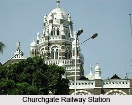
 Churchgate Station is located downtown of South Mumbai. It is a terminus of the Western Railway line of Mumbai suburban railway. It is also the southernmost railway station of Mumbai. It is home to the Western Railway headquarters. Churchgate Station was named after the words Church and Gate. Church denotes the St. Thomas Church placed by the same road about half a kilometre away. It was built during the 18th century. The gate refers to the age old gate placed on the exact spot where the Flora Fountain stands. These two together outlined the southern limits of Mumbai during the 16th century. But the gate was razed down later as urbanisation was taking place rapidly. Today, the Churchgate Station is reckoned as one of the busiest stations of Mumbai. Every day millions of Mumbai residents avail this depot. The railway station also provides sound connectivity with the other stations of Mumbai. Western Railways use this railway station as their terminus for local trains. The earliest train departs at 4:00 a.m, and the last train at 1:00 a.m.
The reason behind Churchgate`s becoming one of the busiest railway stations, can be attributed to the presence of a large number of educational institutions like, University of Mumbai, Jamnalal Bajaj Institute of Management Studies (One of the best business schools in India), Sydenham College (considered the first and oldest Commerce college in Asia, set up by Lord Sydenham of Combe in 1913, the then mayor of Bombay), Jai Hind College (founded in 1948 by the elders of the Sindhi community who were displaced from Pakistan after the partition of India), K.C. College (founded in 1954 by the Hyderabad (Sind) National Collegiate Board. The college was established with the aim of offering education to refugees), H R College (After establishing K C College, Hyderabad (Sind) National Collegiate Board went on to set up 23 educational institutes in Mumbai. In this manner, they founded the H R College at Churchgate in 1960), Government Law College, Bengalee Girls High School, SNDT Women`s University, Nirmala Niketan, Indo-German Training Centre (IGTC) (the management institute of the Indo-German Chamber of Commerce. It was established in 1991).
Nariman Point is very close to the Churchgate area. Nariman Point is also considered one of the most developed areas in Mumbai. The Marine Drive area is situated in the western side of Churchgate, also known as the `Queen`s Necklace`. The area also comprises some of the high profile sport complexes such as Wankhede Cricket Stadium, Mahindra Hockey Stadium, Brabourne Stadium and Oval Maidan.


