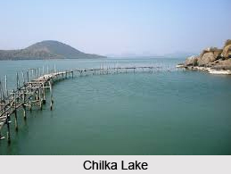
 Chilka Lake in Odisha is actually a lagoon, rather the largest lagoon lying in the east coast of India.
Extension of Chilka Lake
Chilka Lake spreads across Puri, the Gunjam and the Khurda districts of Odisha The lake has been formed at the mouth of the Daya River which flows into the Bay of Bengal.
Geography of Chilka Lake
Chilka Lake is also known as the largest brackish water lake in the country. The area of the lake varies between 1165 kilometers in monsoon to 906 kilometers in the summer season. A number of small islands are spread across Chilka Lake including the two important bases namely the Barkul and the Rambha. Some of the other islands which are spread across the lake are Parikud, Phulbari, Berahpura, Nuapara, Nalbana Bird Sanctuary, and Tampara.
Landforms near Chilka Lake
Chilka Lake was formed due to a silting action in the southern mouth of the Mahanadi River. As the silting action of the river continues till the northern end of the river, the northerly currents in the Bay of Bengal have formed a sand bar along the eastern coast which in turn forms a shallow lagoon. In the year 1981, the Chilka Lake was named a Wetland of International Importance under the Ramsar Convention because as an estuarine lagoon, it supports a unique assemblage of several marine, brackish and freshwater rare and endangered species. Chilka Lake also serves as the abode of several migratory as well resident birds.
Terrain of Chilka Lake
Chilka Lake is a narrow estuary with huge number of mud flats. The western and the southern parts of the lake are overlooked by the hill ranges of the Eastern Ghats Mountain Range in India. A number of inland rivers control the northern end of the lake by bringing silt into it. A barrier beach measuring 60 kilometres and known by the name Rajhensa has been formed by the northerly currents of the Bay of Bengal and this barrier beach in turn has formed the shallow lake. The islands which are found in the lake are separated by narrow channels from each other and the six major islands of the Chilka Lake along with the peninsula of Malud forms the Krishnaprasad Revenue Block in the Puri District.
Depth of Chilka Lake
The depth of water in the lake varies according to the seasons. For instance in the dry season the depth remains 0.3 meter to 0.8 meter whereas in the monsoon the depth enhances to 1.8 meters to 4.2 meters. The lake has been primarily divided into four sectors. The southern, central, northern and the outlet channel area forms the major divisions of the lake and the shape of the lake can be said to be like a pear.
Climate of Chilka Lake
The general climate that prevails in the lake area is of a tropical monsoon variety. Both the south-west and the north-east monsoons are experienced by the lake area in the months of June to September and November to December. 39.9 degree centigrade has been recorded as the highest temperature in the lake and 14 degrees has been the lowest recorded temperature in the areas surrounding the lake. Mostly the catchments area of the lake is formed of silt and the water of the lake is saline and alkaline in nature.
Tourism in Chilka Lake
Chilka Lake is home to various migratory birds. During the winter season around 160 species of migratory birds visit the lake. Large number of birds from Caspian Sea, Aral Sea and parts of Russia and Central Europe crowd the lake during the winter season. The Chilka Lake Bird Sanctuary harbours more than 150 species of migratory and resident birds. The Nalaban Island within the lagoon has also been classified as a Bird Sanctuary under the Wildlife Protection Act. In the Nalban Bird Sanctuary one can witness thousands of birds during the migratory season. The variety of birds includes flamingoes, egrets, black-headed Ibis and many more. A number of rare of species like Dalmatian, Pelican, Asiatic Down witchers and a lot more are also found in this area.
Fishery in Chilka Lake
The lake also has a rich fishery resource amounting to almost 261 varieties of fishes. Even some of the threatened species are found in the lake like the Milk-fish, the Ten pounder, the Bream. The fish reserve of the lake provides livelihood to a large number of fisher men in and around the area. Not only is the lake rich in its fauna but it also has some rare varieties of flora. A recent survey has stated that around 726 species of flowering plants are found in the lake area. A large number of wild plants of horticultural importance and many other kinds of plants are found in the area surrounding the lake.
Visiting Information
The nearest airport to Chilka Lake is Bhubaneshwar which is 120 kilometres from the place. The nearest rail stations here are Balugaon and Rambha that are served well by the South-Eastern Railways. Apart from the air and the rail route, the lake is also well connected by road. It is connected with Chennai and Kolkata by National Highway 5.
As far as visiting the lake is concerned although the lake can be visited throughout the year yet the best time to visit the lake is from October to March.
Related Articles
Resources in India
Water Resources in India
Lakes of India
Odisha, Indian state


