 Formerly known as Madras district or Madarasapattinam, the Chennai District is situated on the north eastern corner of Tamil Nadu along the Coromandel Coast. This region is bounded by the Bay of Bengal and is surrounded inland by the districts of Tiruvallur and Kanchipuram. The district also hosts festivals throughout the year that plays a vital role in the life of the people.
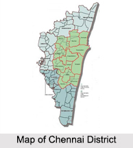
The Chennai District is a city district, which means it does not have a district headquarters. The district was expanded from 178 sq. km to 426 sq. km on September 2018 and aligned with the Greater Chennai Corporation boundary.
History of Chennai District
Chennai was previously known as Madras Patnam and it was situated in the Tondaimandalam province, which was between River Pennar of Nellore and the River Pennar of Cuddalore. The capital of the province was Kanchipuram. Tondaimandalam was ruled in the second century A.D. by Tondaiman Ilam Tiraiyan, who was a representative of the Chola family at Kanchipuram. It is believed that Ilam Tiraiyan must have subdued Kurumbas, the original inhabitants of the area and established his rule over Tondaimandalam. Chennai`s first Governor in the 20th century was Lord Ampthill (1901- 06).
The famous landmarks in this period were the establishment of Chennai Electric Supply Corporation in the year 1906 and opening of Indian Bank in the year 1907. During 1934 and 1936, 2Indians named Sir M.D. Usman Sahib and Sir. K. Venkatareddy Naidu acted as Governors of Chennai. In the year 1937, the Ministry of Chakravarti Rajagopalachari came to power for 2 years. The influence of the Governors on the administration diminished significantly. The British left India on 15th of August 1947 but Chennai remained as a standing monument of the influence of the British over India.
Geography of Chennai District
The Chennai District currently spreads over an area of 426 sq. km and is located on the Eastern Coastal Plains with a total of 2.71 sq. km covering reserved forests. Beyond the district limits in the southwest direction there are few isolated hillocks at the St. Thomas Mount, Pallavaram and Tambaram. The Chennai District runs inland in a rugged semi-circular fashion and its coastline is about 25.60 km, which is about 2.5 percent of the total coastline of Tamil Nadu. The district is also referred to as the Gateway of South India due to its strategic location and economic importance.
The Cooum River flowing in the northern part, the Adyar River flowing in the southern, then along with the Buckingham Canal and the Otteri Nullah carves the district into several islands. Geologically the district is divided into 3 regions, namely, sandy, clayey and hard-rock regions and the soil mainly comprises of clay, shale and sandstone. The district falls under Seismic Zone III indicating a moderate risk of earthquake.
Demographics of Chennai District
As per the reports of Census India 2011, the Chennai District had a population of 8,946,732 with a sex-ratio of 989 females for every 1,000 males, much above the national average of 929. A total of 4,559,324 were under the age of 6 years, constituting 235,519 males and 4,323,805 females. The minority classes like the Scheduled Castes and Tribes accounted for 16.78 percent and .22 percent of the population respectively. The average literacy of the district was 81.27 percent, compared to the national average of 72.99 percent.
With a total of 154,982 households, the total number of workers was 1,817,297 starting from cultivators, agricultural labourers, etc. The expansion of the district announced in 2018 is estimated to increase the population to about 10.71 million.
Administration of Chennai District
After the expansion of the Chennai District in 2018, 6 additional taluks from the Tiruvallur and Kanchipuram districts were added. These new divisions and taluks are divided as per the north, central and south Chennai Revenue Division.


