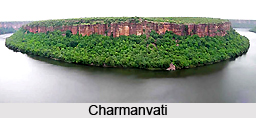
 Charmanvati is the name of a river in Chambal, which is now called Chambal River. The river Charmanvati has been mentioned in the great epic "Mahabharata". The Charmanvati River is a tributary of Ganga River. Many people used to visit this Charmanvati River, mainly who migrated from River Saraswati as it dried up, due to its proximity.
Course of Charmanvati River
The Chambal River is a tributary of the Ganga River in central India, and forms part of the greater Gangetic drainage system. The river flows north-northeast through Madhya Pradesh, running for a time through Rajasthan, then forming the boundary between Rajasthan and Madhya Pradesh before turning southeast to join the Yamuna in Uttar Pradesh state. It is a legendary river and finds mention in ancient scriptures.
Etymology of Charmanvati River
The ancient name of the Chambal was "Charmanvati", meaning the river on whose banks the leather of slaughtered animals was dried. In the epic of Mahabharata, Charmanvati has been originating from the blood of thousands of animals sacrificed by the Aryan King Rantideva. King Rantideva is said to have performed animal sacrifices on the banks of Charmanvati. In due course of time, this river became famous as the river of "chamra" (skin) and was named as Charmanvati.
Mythology of Charmanvati River
The modern name "Chambal" of the river Charmanvati means "fish" in some of the Dravidian languages like Telugu. According to the history of Dravidians, the Matsya Rulers had their origin from the banks of this river. The word Matsya also means fish in Sanskrit. Thus the bank of this river is thought to be the cradle of a fishermen community who later attained kingship.
Charmanvati was the southern boundary of Panchala Kingdom. King Drupada used to rule the Southern Panchalas up to the bank of the Charmanvati River. As per the Mahabharata, Kunti left her new-born baby Karna in a basket and floated it in the river Aswa, which moved to Charmanvati. While marching to the banks of the Charmanvati, the Kuru warrior Sahadeva met the son of king Jamvaka.
In the Mahabharata, the Chambal area was a part of Shakuni"s kingdom. The infamous dice game whereby Shakuni won the kingdom of the Pandavas` for his nephew Duryodhana was played hereabouts. After the attempted disrobing of Draupadi (the daughter of King Drupada) she cursed any one who would drink the water of the Charmanwati River.
Present Scenario of Charmanvati River
The legends of its curse by Draupadi and its bloody "unholy" origins due to King Drupada have helped the Chambal to survive unpolluted by man, and its many animal inhabitants to thrive relatively untouched. The Chambal remains one of India"s most pristine rivers.


