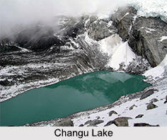
 Changu Lake, or Tsomgo Lake, is a glacial lake in the East Sikkim district of Sikkim. At an altitude of 12,400 feet on the Gangtok-Nathula highway, the lake is absolute picturesque beauty and religiously sacred. The visually striking appeal, peace and serenity of the Changu Lake make it an ideal tourist and picnic spot.
Location of Changu Lake
Changu Lake is located on the Gangtok-Nathula highway, about 40 kilometres from Gangtok, the capital city of Sikkim. The road to Nathu La runs past the edge of the lake towards the north. It is also near to the Indo-Chinese border crossing.
Etymology of Changu Lake
Also known as Tsomgo Lake, it is a concoction of Bhutia terms "tso", meaning lake and "mgo" meaning head, literally referred as the source of water. The lake is the source of the Lungtse Chu River.
Scenic Appeal of Changu Lake
Changu Lake is oval-shaped and about 850 metres long and 450 metres wide. Its reported maximum depth is 15 metres. The beautiful lake is situated in the rift between two peaks. The bluest of skies and surrounding mountains reflect on its surface into the crystal clear waters, making it appear as if a gigantic mirror is placed amidst. Being a glacial lake, it remains all frozen in the winter season. During Weather Season">summers by the month of May, the placid lake derives its water from the melting ice of the surrounding mountains, when the spring"s profusely bloomed rhododendrons, rare primula species, blue and yellow poppies and other alpine plantations, aesthetically add to the lake"s vibrancy.
Also seen in this visually delightful zone are different bird species such as the Brahminy Ducks. Its wildlife includes the Red Panda also.
 Religious Significance of Changu Lake
Changu Lake is associated with many myths and legends and is considered sacred by the Sikkimese people. Legend has it that the lake"s different colours in different seasons were reference points for the Buddhist monks or lamas in foretelling the future. If it had a dark shade, the future was predicted to be gloomy.
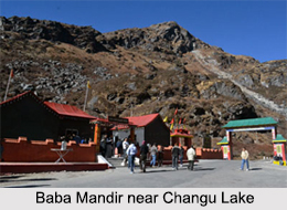
There is a small Lord Shiva temple at lakeside, where devotees pay homage and offer prayers. The "Jhakris" or faith healers of Sikkim assemble here on Guru Purnima, coinciding with the Raksha Bandhan festival, to offer prayers and derive benefit from the lake"s healing waters.
Best Time to Visit Changu Lake
Displaying different views in different seasons, it can be visited during winters, from January to mid May, where its frozen manifestation and snow-covered surrounding mountains can be caught at sight, also trekking, yak and mule rides can be enjoyed at the site, with snacks and beverages available. During October to December, the lake is partly covered in sheet ice and migratory birds can be seen waddling in its waters. From April to July post spring, a vibrant blossom of flowers colour the beauty of the place. Temperature here is never beyond 25 degrees on Celsius scale, going as low as freezing point.
Being in a restricted area, Indian visitors are required to seek permissions to visit Changu Lake, while foreign tourists require special permits.
Visiting Information of Changu Lake
It takes about 2 hours by car from Gangtok to reach the lake. The nearest airport is in Pakyong (Sikkim) which is around 32 km from Gangtok and the nearest railway stations to Gangtok are Siliguri (113 km) and New Jalpaiguri (125 km). From there one can hire a taxi or bus service to come up to Gangtok.


