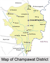
 Champawat District is a rural district in the north Indian state of Uttarakhand. Being a newly formed and remote district no important Research Institution is situated in Champawat District. Only a Krishi Vigyan Kendra of Pantnagar Agricultural University exists at Lohaghat. Champawat District of Uttarakhand was constituted in the year 1997. Champawat town is the district administrative headquarters, which is 76 kms from Pithoragarh headquarters, Champawat is situated 1615 meters above sea level. The long chain of mountain in southwestern region acts as a border between Champawat District and Nainital District. It is important from the defense point of view as the east Kali river acts as the international border between Nepal and India.
Location of Champawat District
Champawat District is situated between 29 degree 5 minutes and 29 degree 30 minutes in northern latitude and 79 degree 59 minutes and 80 degree 3 minutes at the center of eastern longitude. Ram Ganga River acts as a border between Champawat and Pithoragarh in north while Jabgura and Pannar rivers in south and west act as a border between Champawat District, Udham Singh Nagar District and Almora District simultaneously.
History of Champawat District
Champawat District owes its name to King Arjun Deo`s daughter Champawati. As per historical records, initially Champawat District formed a part of Almora District. Further, in the year 1972, Champawat Tehsil was transferred to Pithoragarh. Champawat District was declared an independent district of Uttarakhand on 15th September, 1997.
Geography of Champawat District
The geographical coverage of Champawat District is about 1613 sq km. It includes two Tehsils and four development blocks and 691 revenue villages. Champawat District is rich with natural perennial rivers and rivulets. Because of Lohawati River, Jagbura River, Ramganga River, Kali River and other rivers the region never felt the scarcity of water, but due to uneven geographical condition the major portion of water drains off through small rivers and rivulets. Only about 9 percent of the total land is termed as agricultural irrigated land of the region. The major portion of land is dependent on the rain water only, which has adverse effect on agricultural production.
Climate of Champawat District
 The climate of Champawat District is basically pleasant. Champawat District also possesses various species of flora and fauna. Champawat District is also rich in mineral resources.
Demography of Champawat District
According to the Population Census in the year 2011, Champawat district has a population of 259,648. Champawat District has a population density of 147 inhabitants per square kilometer.
Economy of Champawat District
In Champawat District 65 percent of the area is under forest and net sown area is less than 10 percent. Only about 9 percent of the sown area is irrigated and agriculture is manly rain fed. Consequently, it is at a subsistence level and only traditional crops are grown. Around 82 percent of workers are engaged in agriculture and there are negligible workers in household or non household industries. Thus, economy of Champawat District is based on agriculture and to some extent on minor forest produce and vegetable production.
Lack of agricultural land and resources has always been a reason for the poor economic status of the rural areas of the district. The agricultural production is less as compared to the effort put in. The economic condition of Champawat and Lohaghat is comparatively better due to seasonal production of fruits.
A few males are involved in conventional traditional work for the maintenance of livelihood, such as pottery, carpentry, blacksmith etc. Few villagers are also involved in animal husbandry. There are no small or medium scale industries in the region. As a result majority of population of the youth are unemployed.
Champawat District is characterized by money order economy as a large number of males are working outside in big cities like Delhi, Lucknow, Mumbai, etc. either in the armed forces or other jobs since there are very less employment opportunities in the district. Champawat District is economically and socially backward with acute poverty and society ridden with outmoded traditions and even superstitions.
Tourism in Champawat District
Tourism in Champawat District includes some of the important tourist attractions like Kranteshwar Mahadev Temple, Ek Hathiya Ka Naula, Patal Rudreshwar, Reetha Sahib, Baleshwar Temple, Banasur Ka Kila, Nagnath Temple and Abbott Mount Church.
Visiting Information
The nearest railway station is 75 km away from Champawat at Tanakpur. The urban and semi urban towns are well equipped with roads. In the field of telecommunication the urban area of the district is equipped with the modern telecom facilities whereas the rural areas are still untouched with this facility. Champawat District has poor healthcare facilities.


