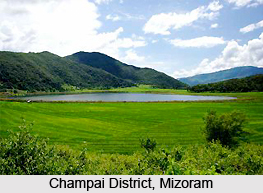
Champai is amongst the eight districts of the Eastern Indian state of Mizoram and is surrounded by the district of Churachandpur, Manipur towards the northern side and Serchhip and Aizawl district on its western side. The total area of Champai measures about 3185.83 square kilometres. The town of Champai is the administrative headquarters of Champai district.
 Geography of Champai District
Champai experiences a moderate climate. During summer, the temperature hovers around 15øC and 30øC while during winters, the temperature drops to nearly 10øC to 20øC. The Murlen National Park was established in the Champai district in the year 1991. It occupies an area of about 200 square kilometres. Champai also possesses the renowned Lenteng Wildlife Sanctuary which was set up in 1999 and has a total area of 120 square kilometres.
Administration of Champai District
Ngopa, Champhai, Khawzawl and Khawbung are the four Rural Development Blocks in Champai district. The five Legislative Assembly constituencies administered by this district are Khawbung, Ngopa, Khawzawl and Khawhai. This district possesses 88 villages.
Demography of Champai District
According to the 2011 census, the total population of Champai district is 1, 25, 745. The aggregate number of males here amount to 63,388 while the number of females are 62, 357. The literacy rate of Champai district measures about 95.91%. The sex ratio in 2011 stood 984 females per 1000 males.
This article is a stub. You can enrich by adding more information to it. Send your Write Up to content@indianetzone.com


