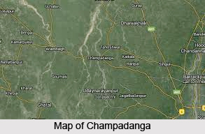
 Champadanga is a suburban area under Tarakeswar block and a police station in Chandannagore subdivision of Hooghly district in the Indian state of West Bengal.
Location of Champadanga
Champadanga is located at 22.83 degree north to 87.96 degree east.
Demography of Champadanga
Champadanga has a small population of near about 1,214. They are mostly Hindus and Muslims.
Economy of Champadanga
Champadanga is a rich agricultural area with various cold storages. The chief products here are potato and rice.
Education of Champadanga
Rabindra Mahavidyalaya, Champadanga High School, Naskarpur Netaji Prathamik Vidyalaya, Champadanga Bijay Krishna Uchcha Balika Vidyalaya, Muktarpur High School (H.S) and Muktarpur Khyantamayi Prathamik Vidyalaya are the several schools in Champadanga.
Transportation in Champadanga
In 1897, the Howrah-Amta line of Martin`s Light Railways was opened up to Domjur and to Amta in 1898. In 1904, an extension from Bargachhia junction to Antpur was opened and a further extension to Champadanga was opened in 1908. The lines were functional until 1971. The new Howrah-Amta broad gauge line project including the Bargachia-Champadanga branch line was sanctioned in 1974-75. The first 24-km stretch of the section from Howrah to Bargachia was completed in 1984 by South Eastern Railway and commissioned soon after. The 6 km long Bargachhia-Munsirhat stretch was inaugurated in 2000. The Mahendralal Nagar-Amta section was finally opened in 2005. However, the Bargachhia-Champadanga branch line is yet to be completed.
Communication in Champadanga
Champadanga area exchanges with code 3212 and serves Jinpur, Eksara, Haripal, Chanditala, Begampur, Harinkhola, Masat, Bhagabatipur, Shaympur, Dwarhatta, Muktarpur, Dihi-badpur, Gopinagar, Jangipara, Nalipur, Rajbalhat and Tarakeswar.
This article is a stub. You can enrich by adding more information to it. Send your Write Up to content@indianetzone.com
Related Article:
Indian Villages
Villages of West Bengal
Begampur
Dwarhatta
Eksara
West Bengal


