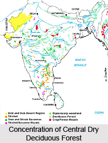
 The Central Deccan Plateau dry deciduous forests in India are an integral part of the Deccan Plateau that is a large triangular plateau, situated in southern India. The forests together form a Tropical dry broadleaf forest ecoregion. The Deccan Plateau is bounded by the Western Ghats range to the west, the Eastern Ghats range to the east, and the Satpura Range to the north. Apart from the Tapti River in the northwestern corner, most of the rivers on the plateau drain east towards the Bay of Bengal. The Tapti River drains westward into the Arabian Sea. The Central Deccan Plateau dry deciduous forests in India cover a huge area of 240,200 square kilometers and are located on the central portion of the plateau.
The Central Deccan Plateau dry deciduous forests in India lie mostly within the states of Maharashtra and Andhra Pradesh and also extend into adjacent parts of Madhya Pradesh and Chhattisgarh. The forests cover most of the Vidarbha region, including the city of Nagpur, in the state of Maharashtra. Much of the Telengana region, including Hyderabad, the state capital, with a small portion extending across the Eastern Ghats to the Arabian Sea in Krishna District, is being covered by these forests, in Andhra Pradesh. To the west, south, and southeast of these forests, there lie the xeric Deccan thorn scrub forests that cover the drier portions of the plateau in the rain shadow of the Western Ghats. While the more humid Eastern highlands moist deciduous forests lie to the northeast and east of the forests, the Narmada Valley dry deciduous forests lie across the Satpuras to the northwest.
The Central Deccan Plateau dry deciduous forests in India are neither exceptionally species-rich nor high in numbers of endemic species. However, they still contain about 20 percent of its natural habitat as several large blocks, some of which exceed 5,000 Sq km. The ecoregion is characterized by a high human population density and the presence of several large vertebrate species. The large habitat blocks in these forests have been recognised as high-priority landscapes for a long-term Tiger conservation strategy. For this, the forests are making an important contribution to a regional Tiger conservation strategy.
 The vegetation type of the Central Deccan Plateau dry deciduous forests in India is distinct from the Teak or Sal dominated dry forests that cover most of the Deccan Plateau. The forests have an upper canopy at 15-25 m and an understory at 10-15 m. Though, the Lianas drape the trees in mature forests; the undergrowth is sparse. The characteristic tree association in the northern areas of these forests includes the Hardwickia binata-Albizia amara woodland with Tectona grandis, Boswellia serrata, Lannea coromandelica, Anogeissus latifolia, Albizia lebbek, Lagerstroemia parvifolia, Diospyros tomentosa, and Acacia catechu, etc. In the southern areas, the tree association is characterised by Pterocarpus santalinus, P. marsupium, Chyloroxylon swietenia, Terminalia chebula, T. tomentosa, Albizia lebbek, and Dalbergia latifolia, etc.
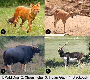
In spite of not being exceptional in terms of endemism and diversity, the Central Deccan Plateau dry deciduous forests in India harbour several of India`s large, threatened vertebrates. The species include the Tiger, Wild Buffalo, Wild Dog, Sloth Bear, Chousingha, Gaur, Blackbuck, and Chinkara (IUCN 2000). The large habitat blocks in the forests provide an opportunity to conserve these wide-ranging species whose populations are fast declining throughout most of their ranges because of habitat loss and hunting. The forests are also home to eighty-two known mammal fauna and none of the species is considered as endemic to the ecoregion. Apart from the larger, threatened mammal species mentioned earlier, the forests also harbour the threatened Malabar Squirrel (IUCN 2000).
The Central Deccan Plateau dry deciduous forests in India have a richer bird fauna in comparison to the rich variety of mammal species. The forests provide habitat a total of almost 300 bird species, out of which, only one is considered as globally threatened. The species is Jerdon`s Courser and it is also considered as a near-endemic species. After being recorded in 1900 for the last time, this species was rediscovered in 1986. Apart from these forests, the small distribution range of the only known population of this rare species also extends across the neighboring Deccan Thorn Scrub Forests.


