Home > Indian History > Geography of India > Cardamom Hills
Cardamom Hills
The Cardamom Hills are known for producing tea, coffee, teak, bamboo and cardamom.

Share this Article:

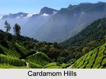
Cardamom Hills, KeralaCardamom hills are a part of the south Western Ghats nestled in the southeast of Kerala and southeast of Tamil Nadu. Anai Mudi is the highest peak in the Cardamom hills. The Cardamom hills are home to tribes like Mudugan, Urumban and Irulan who work in the tea gardens to earn their livelihood. In addition to tea, the hills are known for producing coffee, teak, bamboo and cardamom.

Every year, the eco friendly environment, scented tea gardens and magnificent landscapes of these hills attract tourists from all parts of the world. The Cardamom hills are under consideration by the UNESCO World Heritage Committee for the selection as the World Heritage Site.

Etymology of Cardamom Hills
The cardamom spice is grown in abundance at a higher elevation in the cooler areas of the Cardamom hills and thus the name is derived. The elevation also supports the growth of pepper and coffee.

Location of Cardamom Hills
The Cardamom hills are located in the southern tip of India encompassing the Western Ghats. The hills cover an area of about 2,800 sq. km of mountainous terrain with deep valleys, and include the drainages of the west flowing Periyar, Mullayar and Pamba rivers. The hills conjoin the Anaimalai Hills to the northwest, the Paini Hills to the northeast and the Agasthyamalai Hills to the south as far as the Aryankavu Pass. Western part of the Cardamom hills is in the south- central region of Kerala, consisting of about 26 percent and the other part of the hill extends till Tamil Nadu with an area of about 74 percent.
Cardamom Hills, KeralaClimate of Cardamom Hills
The daily average temperature of the Cardamom hills during winter is 15 degree Celsius and 31 degree Celsius during summer. In the eastern side in the Srivilliputtur Wildlife Sanctuary, the annual rainfall of 2,000 mm to 3,000 mm in Periyar decreases to less than 1,500 mm. On the western side, two- thirds of the precipitation is received during the southwest monsoon from June to September. The areas also receive rainfall from the northeast monsoon between the months of October and December and from pre-monsoon showers between April and May.

Peaks in Cardamom Hills
Mentioned below is a list of peaks in the Cardamom hills:

Peaks Altitude Location
Anamala 8, 842 ft Eravikulam National Park
Meesapulimala 8, 660 ft Munnar
Kattumala 8, 373 ft Idukki
Devimala 8, 278 ft Devikulam
Kumarikkal Mal 8, 274 ft Chinnar Wildlife Sanctuary
Eravimala 7, 900 ft Munnar
Nandala Mala 7, 782 ft Marayar
Kottakombu Mala 7, 034 ft Chinnar Wildlife Sanctuary
Kottamala 6, 624 ft Thekkady
Karimkulam 8, 481 ft Munnar
Pambadum Chola 7, 999 ft Vattavada
Karimala 6, 900 ft Idukki
Devicolam 6, 990 ft Devikulam
Vagavara 7, 900 ft Idukki
Anchanad 7, 100 ft Idukki
Peradu Mala 7, 300 ft Idukki
Ghudoor 7, 900 ft Idukki
Kabula 7, 201 ft Idukki
Mukuthi Mala 8, 400 ft Munnar


Attractions of Cardamom Hills
The Periyar wildlife sanctuary, which is, located in the low-lying Cardamom hills form an important centre of attraction. Here, the Periyar Lake which is an artificial lake covers an area of 5,500 hectares. The sanctuary occupies 777 sq km, out of which the forests cover an area of 360 sq km. The forest vegetation is semi evergreen, the grasslands are typically Savannah and 171 species of grass and 143 species of orchids are present in the sanctuary.

Animals include Gaur, Wild Boars, Sambar Deer, Bison, Barking Deer, Wild Dogs, Lion Tailed Macaque, the Nilgiri Langur, Bonnet Langur and Tigers and the bird species include Hornbills, Storks, Woodpeckers, Kingfishers, Cormorants and Darters.

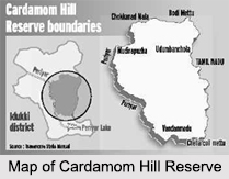
There is also the Cardamom Hill Reserve, which comprises of about 15, 721 acres and is bordered by the Tamil Nadu border to the east, Periyar Wildlife Sanctuary on the south, the Periyar River on the west, and Bodimettu, Chokkanad and Muthirapuzha to the north. The rain forest of the hill reserve are a natural wildlife corridor to Periyar National Park from the Anaimalai Hills and Palani hills of Tamil Nadu and is the catchment area of 6 major hydro-electric projects in Idukki District. Currently, it is situated in the Idukki District of Kerala.

Trekking in Cardamom Hills
The Cardamom hills offer fine scope for adventurous activities like trekking. The trekking exercise leads one through the beautiful valleys, wildlife parks and dense forests and through the fragrant tea plantations.


Share this Article:

Related Articles

More Articles in Geography of India


Geography of Uttar Pradesh
The fourth largest State in India UP is located in the Northern part of India whose area is 2,36,286 sq Kms.
Geography of Maharashtra
Covering an area of 308,000 sq. km, Maharashtra, the third largest state in India.
Geography of Kerala
Geography of Kerala includes plains, hills, valleys and coasts. With the Arabian Sea in the west, the Western Ghats in the east and networked by several rivers, Kerala enjoys diverse geographical features.
Geography of West Bengal
The geography of West Bengal is unique with high peaks of the Himalayan range in the north, the Bay of Bengal in the south and the remaining region is covered with both plains and plateaus.
Geography of Jharkhand
Geography of Jharkhand is comprised of the rich mineral resources and the highly agricultural prospect in this state.
Geography of Sikkim
Geography of Sikkim is characterised by a vast array of magnificent hillock that extends from one corner of the state to the other.
Geography of Meghalaya
The suitable climate, highland plateaus, rivers and the flora and fauna together forms the geography of Meghalaya.
Geography of Mizoram
Mizoram is surrounded by hills, valleys, rivers, waterfalls and lakes. The hills range from 1000 meters to 2000 meters. Rivers, lakes and waterfalls also play major role in forming the land of Mizoram.
Geography of Jammu & Kashmir
Jammu and Kashmir is encompassed by valleys. Some of the dominant valleys of the state are Kashmir Valley, Tawi Valley, Chenab Valley, Poonch Valley, Sind Valley and Lidder Valley etc. Jhelum River is the only major Himalayan River which flows through the Kashmir valley. Indus, Tawi, Ravi and Chenab Rivers are the major ones flowing through the region.
Geography of Daman and Diu
Daman and Diu is situated on the west coast of India and are the smallest union territories of India.
Geography of Goa
Geography of Goa occupies a prime location along the Konkan coastal belt on the western coast of India. The state is bordered by Maharashtra in the north and Karnataka in the south. The Western Ghats in the east contribute to the flora and fauna of Goa.
Geography of Arunachal Pradesh
Geography of Arunachal Pradesh reveals that it is a hilly tract nestled in the foot of Himalayas.
Geography of Kutch
Geography of Kutch District is covering an area of 45,612 km. Kutch District is the largest district in the state of Gujarat.
Geography of Ladakh
Geography of Ladakh mainly comprises the huge Karakoram Range with long stretch of cold desert which mark the region separately from the rest of the states of Indian subcontinent. Surrounded with the mountain ranges from all corners this small region separates Indian subcontinent from rest of the Asian continent.
Geography of Rajasthan
Geography of Rajasthan defines the dry topography with arid climate of the western mountain region.
Geography of Tamil Nadu
The Indian state of Tamil Nadu is located in the Northern hemisphere in the hot zone.